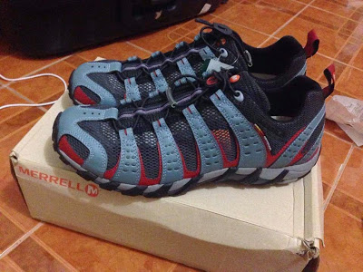
Quantcast
Channel: Pinoy Mountaineer
Viewing all 613 articles
Browse latest View live

Mountain News: 5 hikers dead in river crossing incident in San Jose, Tarlac; one missing

$
0
0
FILE PHOTO: The river in Brgy. Iba, San Jose, Tarlac
We have received reports, both from media and from hikers familiar with the ongoing developments, that a group of hikers got caught in a flashflood on August 30 while crossing a river in Sitio Baag, Brgy. Iba, San Jose, Tarlac. Sitio Baag is home to the "San Jose Circuit" - a trail that runs through three mountains: Mts. Tangisan, Kawayan, and Bungkol Baka. The hikers, who were joining an outreach to the Aeta community in the area  were reported to be descending from Mt. Kawayan when a flashflood swept them from the river they were trying to cross. One source told us that they were using a rope.

Five hikers were reported dead and one is still missing. An Inquirer report identified the victims as Mark Raven Villanueva, Rocky Sumalinog, Jose Bernadette Ramirez, Jo Marie San Diego and Doreen Adriano. Several others were reported injured. Contrary to an earlier report by ABS-CBN (which has since been amended), none of the victims belonged to the UP Mountaineers, who took part in the search and rescue operations.

The river in question - Pangasahan River in some accounts - is known to swell during the rainy season.

Flashfloods are the leading cause of hiking-related deaths in the Philippines. In September 2011, hiker Adrian Alba was swept by strong currents in Rodriguez, Rizal. In 2008 and 2009, two incidents in Anawangin Cove in Zambales also involving river crossings, also claimed the lives of several hikers.

The mountaineering community has taken to social media to express sympathies over this tragic accident. We are praying for the safety/rescue of missing hiker, speedy recovery for those who were injured, and comfort for the families of the victims.

For updates and/or feedback please contact gideon@pinoymountaineer.com.

Hiking matters #473: Introducing Mt. Tumanoktok (1260m) in Mayoyao, Ifugao

$
0
0
MAYOYAO, IFUGAO - One day after the trek up historic Mt. Nagchajan (see Hiking matters #472), I was joined by my hiking buddy Coby Sarreal and rock climber Onyx Calago on another hike in Mayoyao, this time up the little-known Mt. Tumanoktok. Coby and Onyx had trekked in the past couple of days from Cambulo-Batad-Bangaan and we met in Helen’s Homestay where in Mayoyao where I had been staying since Thursday. After an early breakfast we walked down the road towards Mayoyao Hostel, and began the hike to Tumanoktok.

With wide paths, expansive views, and pine trees, Mt. Tumanoktck can be called a “mini Mt. Ugo", in the same way that I likened Nagchajan to Amuyao. Tumanoktck, however, is a more serious hike compared to Nagchajan in terms of mileage. Still, it was a very enjoyable route very much reminiscent of the section from Indupit to Domolpos. This time, instead of views of Nueva Vizcaya, we could see the villages and rice terraces of Mayoyao, including those of Chaya and Mt. Nagchajan on top — and all the way to the mountains of Aguinaldo, Ifugao and the peripheral peaks of the Cordilleras as they empty into the plains of Isabela.

After several meanderings, and an eroded portion which provided the only really tricky part of the hike, the trail becomes more forested, and at times we were surrounded with pines. A moderately steep ascent leads to the summit, which has two huts, a bench, and a pine tree - all of which make it not just a great viewpoint but also a place to hang out. Ah - how I wish there was time to just go up there and read one of my favorite Gabriel Garcia Marquez novels!

A stone marker that shows that the summit is the actually the boundary of three different barangays. I measured an elevation of 1260m - making for an altitude gain of around 300 meters. Past the summit we saw a trail that opens up the possibility for a traverse to the east, going down one of the lower barangays of Mayoyao. But that will be for another time.

In all, it took us 1.5 hours to reach the summit, while the decent was just as straightforward, taking less than an hour. Even though I will miss Mt. Amuyao via Mayoyao (this will be for next time), I feel very fulfilled having done two new peaks in the Cordilleras, not to mention three days of trekking around the rice terraces, beautiful as they are a treasure trove of cultural heritage. Thank you Mayoyao! I will be back soon.


TWO DAYHIKES IN MAYOYAO, IFUGAO (2015)
Hiking matters #472: Mt. Nagchajan
Hiking matters #473: Mt. Tumanoktok

Mountain News: Cristobal closed in all trails - PASU Sally Pangan

$
0
0
Ms. Sally Pangan, PASU of Mts. Banahaw-San Cristobal National Park, has sent us the following message:

"This is to inform everybody that all trails going to the peak of Mt. Cristobal is closed whether it is in quezon or laguna side..the PAMB had decided to close this part of the mountain because of the fire incidence which happened in 2013. Trekkers/mountaineers were advised not to take risk in ascending the said mountain." 

Violators will be dealt with according to laws, rules and regulations imposed by PAMB....only researches and scientific studies of scientist, students and professionals are allowed where PAMB permit shall be secured first prior to the visit at Mt. Cristobal....for information and guidance of all concerned."

Ms. Pangan did not specify a date for the possible reopening.

This comes a week after hikers were arrested for climbing the mountain via the Dolores trail. Bottom line: Avoid Cristobal for now.

Hiking matters #478: Big Bend National Park, Texas Part 3 - The famed "Window"

$
0
0
AUSTIN, TX - Our third and final hike in Big Bend was another 'moderate dayhike', this time to the famed 'Window' - a literal window that offers a spectacular glimpse of Mexico. It starts right from Chisos Mountain Lodge, which is very comfortable for us as our cabin is right at the trailhead!

As in hikes in Grand Canyon, what's unique about canyon hikes is that the descent comes first. So you might be misled into thinking that you're doing an easy hike, only to have to pay for it on the way back, with no summit-induced adrenaline to boost your energy (though sometimes, the steak at the lodge restaurant can be just as motivating!)

When we started the hike it was already very hot. The trail had the usual mix of cacti, desert shrubs, and occasional juniper, oak, and pine, but in the lower reaches there was a shaded portion that reminded me of woods in Athens surrounding the Parthenon.
The trail was actually unremarkable, but it at the very end where you will see the reward. After trekking underneath some amazing rock formations, one reaches the only opening in the entire Basin rim, and here the view, although confined to a narrow lacuna, is magical. It's as if a door to a whole new world were opened, after living in the darkness for a long time.

Anyway this is just a very short (and rather unexpected) trip to the US and I'm happy that I managed to squeeze in these hikes in a national park I never even knew existed. But Big Bend has turned out to be a special place and will surely remember it fondly. Thanks to my sister Christine for joining me and organising our family's Big Bend adventure!


BIG BEND NATIONAL PARK | SUMMER 2015 
Hiking matters #476: Chisos Basin and Window View Sunset
Hiking matters #477: The Lost Mine Trail
Hiking matters #478: Hike to the famed 'Window'


River Crossing Accidents: Why They Happen and How They Can Be Prevented

$
0
0
A group of river guides practices the turtle formation during a training exercise
on the Upper Chico River in Mt Province. This group was not able to compete the
crossing and had to retreat and move to a different location
by Steve Rogers

Last month's tragic drowning of five hikers in San Jose, Tarlac is a wake-up call for the mountaineering community to raise awareness of river safety in the Philippines. In this article, longtime outdoorsman and rafting instructor Steve Rogers, who has lived in the Philippines for several decades, talks about and makes a case for the importance of swiftwater training.

River crossings have emerged as the leading cause of fatal accidents in the Philippine hiking/mountaineering community. Consider the record:
- June 2008: 3 hikers drowned attempting to cross a river in Pundaquit, Zambales
- August 2009: 2 hikers drowned attempting to cross the same river in Pundaquit, Zambales
- September 2011: One hiker drowned trying to cross the Wawa River in Montalban during a training exercise
- August 2014: 7 Bulacan State University students drowned in a flash flood while attempting a crossing of the Madlum River.
- August 2015: 5 hikers drowned in a flash flood while attempting a river crossing during a hike in San Jose, Tarlac

Perhaps not all of those who died were “mountaineers”. They may not have passed a BMC or been members of an established outdoor organization. Still, they were engaged in hiking as outdoor recreation, and (in my opinion only) the frequency and death toll of river crossing accidents requires an organized response from the outdoor recreation community. One life lost in the pursuit of outdoor recreation is one too many. 17 young people dead in 7 years in river crossings alone is simply unacceptable. We cannot change the climate or geography of the Philippines. Our mountains often receive abrupt extremely intense rainfall. Many of our watersheds are degraded and prone to rapid runoff. Flash floods will happen. The behavior of water won’t change, but the behavior of people can. Awareness can be upgraded, risk assessment and decision making can be improved, new techniques and standards can be adopted and taught. It will take time and effort, and even with maximum effort there is no assurance that every incident can be prevented… but doing nothing is little more than an assurance of more deaths.

My proposal derives from a position straddling multiple outdoor communities. I grew up in the mountains and have been hiking the Philippine mountains since the 1980s. I’ve also been involved in white water kayaking and rafting for several decades, a process that has led to involvement in swiftwater rescue training for both river guides and first responders. My suggestion is simply that the skills and knowledge of the river recreation and swiftwater rescue communities can be transferred to improve river crossing safety practices in the trekking/mountaineering community.

Modern swiftwater rescue involves an extensive body of knowledge and practice developed in a collaborative effort between the whitewater recreation community and the first responder community. Much of what river guides and rescuers study and practice is not relevant to mountaineers, but there are many elements of swiftwater rescue, most notably river mobility, river crossing, and site evaluation and preparation methods, that are directly applicable and could significantly upgrade safety practices in the hiking/mountaineering community.
How to communicate and spread this body of knowledge is a more difficult question. One proposal begins with reassessing and upgrading the river crossing component of the Basic Mountaineering Course (BMC). That of course is not enough, as many of the groups in the field today do not contain a single person who has taken a BMC, but the BMC remains the primary vehicle for disseminating knowledge in the trekking/mountaineering community and this remains a viable starting point. Other options include making training available to groups and trip leaders, and simply spreading awareness that better practices exist.

What Goes Wrong… and How to Change It
Reviewing the incidents listed above reveals obvious common factors. One incident occurred in late June, three in August, one in September: all during rainy season. Most incidents occurred late in the day, when probability of rain in upland areas is highest, and when tired groups eager to get back to shelter are vulnerable to poor decision making. All of the events occurred within a day’s trip of Manila, on relatively easy routes that attract large groups of less experienced hikers. Three incidents involved voluntary entry into already hazardous waters (two in an effort to get home, one in a training exercise), two involved the unanticipated hazard of flash floods occurring during a large-group river crossing.

The first step toward preventing accidents – and the first part of any swiftwater-related training – is developing a better understanding of what moving water is, how it behaves, what factors influence it, and how to predict its behavior. Despite its apparent chaos, moving water is in fact highly predictable, and understanding that is the first key toward reducing accidents. A half day in the classroom, supported by subsequent in-water exercise, is sufficient to communicate the essential concepts.

Before any swiftwater training addresses technique, attention has to be paid to decision making, and to the most important (and in some cases irrevocable) decision you can make in a swiftwater situation: to enter the water or not to enter the water. The first and best advice in a high water river crossing situation is simply “when in doubt, wait it out”. Water that rises fast will typically fall just as fast. You may be cold, you may be wet, it may be getting dark, and that river may be the only thing between you and comfort… but you can live over a week without food, under a minute without oxygen. If a river is visibly flooded, discolored, with floating debris, if the depth is not possible to determine, if you have any doubt at all over whether the group has the expertise, strength, and equipment needed for a safe crossing… retreat to higher ground and wait. Do not attempt foot crossing of fast moving water that is above crotch-deep on the shortest member of the group, even using the cluster crossing techniques taught in swiftwater rescue classes. If a crossing is already in progress and the water turns out to be deeper or more powerful than expected, retreat and reconsider. Risk assessment at this stage includes both immediate risk – hazards actually present in the conditions observed – and potential risk of rapidly changing conditions, based on season, time of day, observed weather conditions, and river geography. Situational awareness is critical: a summer day with horizon-to-horizon clear skies presents a very different hazard set from a rainy season afternoon with nearby mountains covered in dark cloud. Selecting a site for a river crossing requires experience and training, and should not be done casually or on the assumption that “where everybody does it” is ideal or appropriate.

Once You Decide to Cross…
An actual river crossing is not simply a matter of walking across a river, particularly with a large group, a group with less capable or experienced members, or when actual hazards like strong current and/or deep water are present or when the season, time of day, weather or other factors indicate elevated flash food risk. An unmanaged crossing typically devolves into a string of hikers spread out across a river, with no system in place for early warning of hazards, no capacity for downstream rescue, no overall control or decision making capacity, and no plan. As a result, if emergency strikes there is little warning, and inexperienced individuals have to respond on their own, often leading to panic, paralysis, and tragedy.

Trained swiftwater operators approach any swiftwater event, even a simple river crossing, with a sequence of actions. An overall controller is appointed, typically the most experienced member of the group. The controller devises a plan, usually working with other senior group members. Before anyone actually approaches the water, a spotter is placed upstream with a signaling device (usually a whistle) to warn of floating debris, water level changes, or other hazards. If flash flood risk is judged to be high, a judicious controller might elect to place multiple upstream spotters to give the earliest possible warning, using one spotter at maximum signallable distance upstream from the group, and another farther upstream to relay a warning. Downstream safety is set, using positioned rescuers with throwbags: anyone regularly performing river crossings should invest in a throwbag and in the training needed to use it effectively.

Upstream spotters are instructed to look out for any sign of a surge: sudden discoloration of the water, an unusual wave pattern, an increase in level, even a sudden wind or sound from upstream. Any suspicion of a possible surge, no matter how tentative, must result in an alert and immediate clearance of the crossing. If it turns out that there is no surge, so be it: this is one situation where safe is infinitely better than sorry!

Once the safety measures are in place, the crossing begins… in small clusters of 4 to 5 hikers, with at least one experienced hiker in each group, even if that means some experienced group members must make multiple crossings. This strategy avoids a situation where individuals are strung out without support, and assures that at least one individual capable of rapid decision making is present in each group. Timing of groups is determined by the incident controller, but typically a second group will not move until the first group is past the crossing midpoint. The first group to cross places downstream safety and upstream spotters on their side of the river, allowing the upstream spotters on the origin side to return to the crossing site. Downstream safety on both sides of the river should be maintained until the final group crosses. When all group members have crossed the controller calls in the downstream safety and completes the crossing.

Complicated? A bit, yes… but with practice these systems become reflex and can be implemented with minimal time and effort. More important, they produce the highest possible probability of a safe crossing, and that’s the goal of the exercise.

Better Ways
Note: a few specific techniques are described here to give an idea of what is possible. They should not be attempted in the field without training and practice. Where moving water is concerned, everything is more complicated than it sounds, and the consequences of error may be immediate and severe.

Smaller groups of more experienced mountaineers may be able to adapt other techniques used in swiftwater rescue. Small groups looking for a more stable way to cross relatively shallow fast water (again, below crotch deep on the shortest group member) can use what we call a turtle: a group, typically of 4, supporting each other during a crossing. In a turtle formation one person moves at a time, with the others providing solid support for the moving individual. The turtle requires constant communication among group members, and is as slow as its namesake, but provides a relatively small group with effective support during a crossing. Again, upstream spotters and downstream safety should be in place.

One of the most frequent and dangerous mistakes hikers make is the misuse of rope. A rope, properly employed, can be a vital tool, and at times a lifesaver. Used wrong, a rope can be deadly, and can provide a dangerous and false sense of security, encouraging people to enter dangerous situations by convincing them that the rope makes them safe.

The first rule of using rope in fast water is that nobody should ever be tied to a rope, the sole exception being the use of a purpose-built rescue PFD with an integrated breakaway harness enabling the user to release from the rope at will. There are few faster or more reliable ways to die in swift water than to be tied to something: the typical end result is the tied individual being spun, thrashed, and forced down by moving water, with drowning resulting in short order.

Another common error in rope-assisted river crossings is to tie a rope directly across a river and attempt to use it for support in a foot crossing, sometimes even referring to it as a “lifeline”. This is a dangerous and inappropriate tactic that should not be used. No matter how tight the rope is tied, it will always sag downstream under pressure, forcing the hikers using it as support to work upstream, fighting the current, on the second half of their crossing. A hiker that loses footing while holding a rope in swift water will pivot downstream around the axis of the rope, ending up in a “superman” position, unable to force their legs back to the bottom against the current. Eventually – usually quite quickly – they will let go.

If you are planning a rope-assisted river crossing, remember a basic principle: do not fight the water. If your plan or strategy relies on people fighting against current, it’s a bad plan and it will probably fail, potentially catastrophically. When people fight water, people lose. The goal is to understand what the water is doing, work with it, and use its power to help you.

In most cases, if water is deep enough or fast enough to require a rope, individuals making the crossing should not touch the bottom of the river. Putting feet down in fast water has inherent risks: the bottom is where the rocks, snags, and other obstacles are, they often cannot be seen and they can damage and entrap feet and legs.

There are multiple ways to achieve this, all of which require training and practice, and typically at least one person with enough swiftwater swimming skill (a quite different discipline from flatwater swimming, and one that requires training and practice) to get to the other side of the river. If that can’t be done safely, the crossing has to be aborted or a different method used.

River guides  in Mt Province practicing an angled rope crossing as part of
a drill simulating evacuation of guests from a pinned raft, supervised by visiting
Canadian instructor Serge Beland. These techniques require training and practice.
One effective rope assisted crossing technique is the pendulum. To use this method upstream spotters and downstream safety are placed, after which the strongest swimmer in the group gains access to the other side of the river. The actual crossing location should have relatively even current, no rocks or other obstacles, and areas suitable for entering and leaving the water. The swimmer on the far side tosses a throwbag across, and from an upstream position belays the successive swimmers across. The swimmers lie on their backs, feet downstream, with the rope over one shoulder, the shoulder closest to the bank they are leaving. In this position the force of the current will swing the swimmer across the river very quickly and much more safely than in a foot crossing. Again, the second person to cross sets downstream safety on the far side of the river, the third acts as upstream spotter, allowing the initial upstream spotter to return to the crossing area, and the downstream safety person on the near side crosses last, maintaining downstream safety on both sides of the river as long as possible.
Another effective method is the angled rope, in which a rope is suspended tightly (a z-drag may be used to achieve tension) across the river at a steep downstream angle, at least 45 degrees, just above the surface of the water. Once the rope is in place, which again requires one person to cross unassisted, each swimmer places a carabiner or pulley on the angled rope, with a short tail of rope or webbing attached. The swimmer holds the tail over the shoulder closer to the bank they are leaving. If the rig is correctly deployed, the force of the current will slide the swimmer down the angled rope and across the river to the designated receiving zone. Both of these methods allow backpacks to be sent across the river apart from their owners. In both of these techniques strong current is actually an advantage, as they rely on the force of the current to move the swimmer across.

Prevention is Best
In retrospect, each of the fatal incidents cited above was preventable. That comment is not meant to blame anyone, it’s simply a statement of fact, and a reason to change the way the Philippine outdoor community addresses river crossings. Both of the Zambales incidents would have been avoided if the individuals had decided to wait until the water receded, even if that meant spending a miserable night out in the rain. The Wawa incident could have been prevented by properly equipped downstream safety and proper rope assisted crossing technique. The victims in the flash food incidents in Bulacan and Tarlac would have had a far greater chance of surviving with upstream spotters and downstream safety and an effectively organized crossing plan in place.

Simple steps to save lives:

Hikes involving river crossings should be avoided during bad weather, or even rainy season. LGUs and guide groups may wish to consider closing potentially hazardous routes at some times. The trek will still be there in dry season.

The decision to cross a river must be critically evaluated with awareness of actual and potential hazards. When in doubt, wait it out.

Once a decision to cross is made, act systematically. Appoint a controller, develop a plan, set upstream and downstream safety, and execute the plan. Don’t be afraid to change the plan if conditions change or if the original assessment of conditions proves inaccurate (for example, if water turns out to be deeper or faster than originally believed).

Trip leaders and guides should plan ahead and bring the equipment they will need. Anyone who can afford a tent and backpack can afford a throwbag, a good whistle, even a z-drag kit and personal carabiners or pulleys.

Seek training in moving water operations, learn the appropriate skills, and practice them whenever possible.

Be open to new knowledge and new methods. Sometimes the biggest obstacle to knowledge upgrades can be experienced individuals who insist that they already know… I have personally experienced being rebuffed with “sino ka, kami ay mga instructor dito” when pointing out potentially dangerous errors in a river crossing setup.

The current obstacle, of course, is that no systematic training in these disciplines is currently available. The capacity exists: river guides in Mt Province and CDO can modify their own training regimes to serve hikers, and increasing numbers of rescue operators in Manila are developing a swiftwater capacity that again could be modified to serve the hiking/mountaineering community. If these organizations pool their knowledge and resources and develop a standard curriculum and training method, it would be possible to disseminate the needed skills in a systematic and effective way. It won’t happen overnight, and the sad truth is that even if the process starts tomorrow there are still likely to be needless deaths before it can take full effect. Again, though, doing nothing is just a guarantee that more people will die.

The proposal, then, is simple: the river community and responders with swiftwater rescue experience can join together and develop a training program designed to enhance river crossing safety for hikers and mountaineers. The mountaineering and hiking community can organize themselves to train and to disseminate these methods and skills be training more trainers. It will require cooperation, effort, and time… but if it saves even one life, wouldn’t it be worth it?

(UPDATED) Mountain News: Missing hiker Alex Lagata rescued in Mt. Marami

$
0
0
According to hiker Ramon Obmerga, this is the area in Mt. Marami where
they saw mising hiker Alex Lagata, at approximately 1200H on Sunday
Hiker Alex Lagata, who was reported to be missing in Mt. Marami since Sunday morning, was found/rescued on September 30, 2015. Maragondon, Cavite LGU announced that the rescue was done through the efforts of the LGU, WISAR, PNP, and the Philippine Marines. Here are live updates: 


Another photo shared by
Ramon Obmerga


1300H, 9/30/2015: We are pleased to relay the good news that Alex Lagata, the hiker who had been reported to be missing in Mt. Marami, was rescued and found safe today. Kudos to the rescuers, including elements of the Maragondon LGU, WISAR, PNP, Philippine Marines, and various mountaineers.

2200H, 9/29/2015: Still no sign of Alex Lagata, the solo hiker who has been missing Mt. Marami since Sunday. Based on reports of hikers who were in the mountain over the weekend, he was seen on Sunday 0600-0700H on the way to the summit, and again at 1200H as he was making a descent. Meanwhile rescue operations are being mobilized. We wish the SAR volunteers success, and pray that Alex will be rescued/found safe as soon as possible.

2100H, 9/29/2015: Hiker Ramon Obmerga shares photos in the location where they last saw Alex: "We were going up and he was descending. He asked directions from the guide. He was barefoot."

1700H, 9/29/2015: We have been notified that a solo hiker, Alex Lagata, has been missing in Mt. Marami since Sunday morning. Am verifying if SAR has been initiated. If you have any knowledge of his whereabouts please let us know.

Special Feature: The mountains of Fernando Amorsolo

$
0
0
Mayon Volcano as depicted by Fernando Amorsolo
Fernando Amorsolo is one of the greatest artists in the Philippines, known for his depictions of the countryside. As a mountaineer, and one who would like to build a collection of mountain art in the future, I am struck by his faithful depictions of Philippine mountains.
In this 1951 Amorsolo painting, the mountains can easily be identified, from left to right: Mt. Atimla, Mt. Kalisungan, Mt. Banahaw de Lucban, Mt. Banahaw, and Mt. Cristobal. Amazingly, he was depicting the scene exactly as it can be viewed from my hometown of Los Baños!

This is a more popular painting, showing the exact set of mountains. Note the similarity between the cloud formations. Today you can still see some rice fields in the area but there are also buildings and subdivisions. 
Here we have another rural scene this time in the shadow of Mt. Arayat. Based on the appearance of the mountain, it looks as if it was viewed from the Zambales side.
The above painting is entitled"Rice Terraces in Baguio", and I suspect that the mountain at the background is Mt. Ugo, because Mt. Ugo looks very much like that if viewed from the "City of Pines" - although it is a bit narrower. Anyway, it's good to wonder about these masterpieces!
This final drawing does not look like any mountain I know - it can be Makiling as viewed from Calauan, although the mountain looks indistinct and Amorsolo would have sought to capture the outline of Mariang Makiling. Alternatively, is it Mt. Pinatubo before it erupted? Looking at Amorsolo's paintings adds a layer of meaning to his work for Filipino mountain enthusiasts. Indeed, hiking can lead us to an appreciation not only of our country, but of our country's artists.

River Crossing Accidents: Why They Happen and How They Can Be Prevented

$
0
0
A group of river guides practices the turtle formation during a training exercise

on the Upper Chico River in Mt Province. This group was not able to compete the

crossing and had to retreat and move to a different location

by Steve Rogers

Last month’s tragic drowning of five hikers in San Jose, Tarlac is a wake-up call for the mountaineering community to raise awareness of river safety in the Philippines. In this article, longtime outdoorsman and rafting instructor Steve Rogers, who has lived in the Philippines for several decades, talks about and makes a case for the importance of swiftwater training.

River crossings have emerged as the leading cause of fatal accidents in the Philippine hiking/mountaineering community. Consider the record:

– June 2008: 3 hikers drowned attempting to cross a river in Pundaquit, Zambales

– August 2009: 2 hikers drowned attempting to cross the same river in Pundaquit, Zambales

– September 2011: One hiker drowned trying to cross the Wawa River in Montalban during a training exercise

– August 2014: 7 Bulacan State University students drowned in a flash flood while attempting a crossing of the Madlum River.

– August 2015: 5 hikers drowned in a flash flood while attempting a river crossing during a hike in San Jose, Tarlac

Perhaps not all of those who died were “mountaineers”. They may not have passed a BMC or been members of an established outdoor organization. Still, they were engaged in hiking as outdoor recreation, and (in my opinion only) the frequency and death toll of river crossing accidents requires an organized response from the outdoor recreation community. One life lost in the pursuit of outdoor recreation is one too many. 17 young people dead in 7 years in river crossings alone is simply unacceptable. We cannot change the climate or geography of the Philippines. Our mountains often receive abrupt extremely intense rainfall. Many of our watersheds are degraded and prone to rapid runoff. Flash floods will happen. The behavior of water won’t change, but the behavior of people can. Awareness can be upgraded, risk assessment and decision making can be improved, new techniques and standards can be adopted and taught. It will take time and effort, and even with maximum effort there is no assurance that every incident can be prevented… but doing nothing is little more than an assurance of more deaths.

My proposal derives from a position straddling multiple outdoor communities. I grew up in the mountains and have been hiking the Philippine mountains since the 1980s. I’ve also been involved in white water kayaking and rafting for several decades, a process that has led to involvement in swiftwater rescue training for both river guides and first responders. My suggestion is simply that the skills and knowledge of the river recreation and swiftwater rescue communities can be transferred to improve river crossing safety practices in the trekking/mountaineering community.

Modern swiftwater rescue involves an extensive body of knowledge and practice developed in a collaborative effort between the whitewater recreation community and the first responder community. Much of what river guides and rescuers study and practice is not relevant to mountaineers, but there are many elements of swiftwater rescue, most notably river mobility, river crossing, and site evaluation and preparation methods, that are directly applicable and could significantly upgrade safety practices in the hiking/mountaineering community.

How to communicate and spread this body of knowledge is a more difficult question. One proposal begins with reassessing and upgrading the river crossing component of the Basic Mountaineering Course (BMC). That of course is not enough, as many of the groups in the field today do not contain a single person who has taken a BMC, but the BMC remains the primary vehicle for disseminating knowledge in the trekking/mountaineering community and this remains a viable starting point. Other options include making training available to groups and trip leaders, and simply spreading awareness that better practices exist.

What Goes Wrong… and How to Change It

Reviewing the incidents listed above reveals obvious common factors. One incident occurred in late June, three in August, one in September: all during rainy season. Most incidents occurred late in the day, when probability of rain in upland areas is highest, and when tired groups eager to get back to shelter are vulnerable to poor decision making. All of the events occurred within a day’s trip of Manila, on relatively easy routes that attract large groups of less experienced hikers. Three incidents involved voluntary entry into already hazardous waters (two in an effort to get home, one in a training exercise), two involved the unanticipated hazard of flash floods occurring during a large-group river crossing.

The first step toward preventing accidents – and the first part of any swiftwater-related training – is developing a better understanding of what moving water is, how it behaves, what factors influence it, and how to predict its behavior. Despite its apparent chaos, moving water is in fact highly predictable, and understanding that is the first key toward reducing accidents. A half day in the classroom, supported by subsequent in-water exercise, is sufficient to communicate the essential concepts.

Before any swiftwater training addresses technique, attention has to be paid to decision making, and to the most important (and in some cases irrevocable) decision you can make in a swiftwater situation: to enter the water or not to enter the water. The first and best advice in a high water river crossing situation is simply “when in doubt, wait it out”. Water that rises fast will typically fall just as fast. You may be cold, you may be wet, it may be getting dark, and that river may be the only thing between you and comfort… but you can live over a week without food, under a minute without oxygen. If a river is visibly flooded, discolored, with floating debris, if the depth is not possible to determine, if you have any doubt at all over whether the group has the expertise, strength, and equipment needed for a safe crossing… retreat to higher ground and wait. Do not attempt foot crossing of fast moving water that is above crotch-deep on the shortest member of the group, even using the cluster crossing techniques taught in swiftwater rescue classes. If a crossing is already in progress and the water turns out to be deeper or more powerful than expected, retreat and reconsider. Risk assessment at this stage includes both immediate risk – hazards actually present in the conditions observed – and potential risk of rapidly changing conditions, based on season, time of day, observed weather conditions, and river geography. Situational awareness is critical: a summer day with horizon-to-horizon clear skies presents a very different hazard set from a rainy season afternoon with nearby mountains covered in dark cloud. Selecting a site for a river crossing requires experience and training, and should not be done casually or on the assumption that “where everybody does it” is ideal or appropriate.

Once You Decide to Cross…

An actual river crossing is not simply a matter of walking across a river, particularly with a large group, a group with less capable or experienced members, or when actual hazards like strong current and/or deep water are present or when the season, time of day, weather or other factors indicate elevated flash food risk. An unmanaged crossing typically devolves into a string of hikers spread out across a river, with no system in place for early warning of hazards, no capacity for downstream rescue, no overall control or decision making capacity, and no plan. As a result, if emergency strikes there is little warning, and inexperienced individuals have to respond on their own, often leading to panic, paralysis, and tragedy.

Trained swiftwater operators approach any swiftwater event, even a simple river crossing, with a sequence of actions. An overall controller is appointed, typically the most experienced member of the group. The controller devises a plan, usually working with other senior group members. Before anyone actually approaches the water, a spotter is placed upstream with a signaling device (usually a whistle) to warn of floating debris, water level changes, or other hazards. If flash flood risk is judged to be high, a judicious controller might elect to place multiple upstream spotters to give the earliest possible warning, using one spotter at maximum signallable distance upstream from the group, and another farther upstream to relay a warning. Downstream safety is set, using positioned rescuers with throwbags: anyone regularly performing river crossings should invest in a throwbag and in the training needed to use it effectively.

Upstream spotters are instructed to look out for any sign of a surge: sudden discoloration of the water, an unusual wave pattern, an increase in level, even a sudden wind or sound from upstream. Any suspicion of a possible surge, no matter how tentative, must result in an alert and immediate clearance of the crossing. If it turns out that there is no surge, so be it: this is one situation where safe is infinitely better than sorry!

Once the safety measures are in place, the crossing begins… in small clusters of 4 to 5 hikers, with at least one experienced hiker in each group, even if that means some experienced group members must make multiple crossings. This strategy avoids a situation where individuals are strung out without support, and assures that at least one individual capable of rapid decision making is present in each group. Timing of groups is determined by the incident controller, but typically a second group will not move until the first group is past the crossing midpoint. The first group to cross places downstream safety and upstream spotters on their side of the river, allowing the upstream spotters on the origin side to return to the crossing site. Downstream safety on both sides of the river should be maintained until the final group crosses. When all group members have crossed the controller calls in the downstream safety and completes the crossing.

Complicated? A bit, yes… but with practice these systems become reflex and can be implemented with minimal time and effort. More important, they produce the highest possible probability of a safe crossing, and that’s the goal of the exercise.

Better Ways

Note: a few specific techniques are described here to give an idea of what is possible. They should not be attempted in the field without training and practice. Where moving water is concerned, everything is more complicated than it sounds, and the consequences of error may be immediate and severe.

Smaller groups of more experienced mountaineers may be able to adapt other techniques used in swiftwater rescue. Small groups looking for a more stable way to cross relatively shallow fast water (again, below crotch deep on the shortest group member) can use what we call a turtle: a group, typically of 4, supporting each other during a crossing. In a turtle formation one person moves at a time, with the others providing solid support for the moving individual. The turtle requires constant communication among group members, and is as slow as its namesake, but provides a relatively small group with effective support during a crossing. Again, upstream spotters and downstream safety should be in place.

One of the most frequent and dangerous mistakes hikers make is the misuse of rope. A rope, properly employed, can be a vital tool, and at times a lifesaver. Used wrong, a rope can be deadly, and can provide a dangerous and false sense of security, encouraging people to enter dangerous situations by convincing them that the rope makes them safe.

The first rule of using rope in fast water is that nobody should ever be tied to a rope, the sole exception being the use of a purpose-built rescue PFD with an integrated breakaway harness enabling the user to release from the rope at will. There are few faster or more reliable ways to die in swift water than to be tied to something: the typical end result is the tied individual being spun, thrashed, and forced down by moving water, with drowning resulting in short order.

Another common error in rope-assisted river crossings is to tie a rope directly across a river and attempt to use it for support in a foot crossing, sometimes even referring to it as a “lifeline”. This is a dangerous and inappropriate tactic that should not be used. No matter how tight the rope is tied, it will always sag downstream under pressure, forcing the hikers using it as support to work upstream, fighting the current, on the second half of their crossing. A hiker that loses footing while holding a rope in swift water will pivot downstream around the axis of the rope, ending up in a “superman” position, unable to force their legs back to the bottom against the current. Eventually – usually quite quickly – they will let go.

If you are planning a rope-assisted river crossing, remember a basic principle: do not fight the water. If your plan or strategy relies on people fighting against current, it’s a bad plan and it will probably fail, potentially catastrophically. When people fight water, people lose. The goal is to understand what the water is doing, work with it, and use its power to help you.

In most cases, if water is deep enough or fast enough to require a rope, individuals making the crossing should not touch the bottom of the river. Putting feet down in fast water has inherent risks: the bottom is where the rocks, snags, and other obstacles are, they often cannot be seen and they can damage and entrap feet and legs.

There are multiple ways to achieve this, all of which require training and practice, and typically at least one person with enough swiftwater swimming skill (a quite different discipline from flatwater swimming, and one that requires training and practice) to get to the other side of the river. If that can’t be done safely, the crossing has to be aborted or a different method used.

River guides  in Mt Province practicing an angled rope crossing as part of

a drill simulating evacuation of guests from a pinned raft, supervised by visiting

Canadian instructor Serge Beland. These techniques require training and practice.

One effective rope assisted crossing technique is the pendulum. To use this method upstream spotters and downstream safety are placed, after which the strongest swimmer in the group gains access to the other side of the river. The actual crossing location should have relatively even current, no rocks or other obstacles, and areas suitable for entering and leaving the water. The swimmer on the far side tosses a throwbag across, and from an upstream position belays the successive swimmers across. The swimmers lie on their backs, feet downstream, with the rope over one shoulder, the shoulder closest to the bank they are leaving. In this position the force of the current will swing the swimmer across the river very quickly and much more safely than in a foot crossing. Again, the second person to cross sets downstream safety on the far side of the river, the third acts as upstream spotter, allowing the initial upstream spotter to return to the crossing area, and the downstream safety person on the near side crosses last, maintaining downstream safety on both sides of the river as long as possible.

Another effective method is the angled rope, in which a rope is suspended tightly (a z-drag may be used to achieve tension) across the river at a steep downstream angle, at least 45 degrees, just above the surface of the water. Once the rope is in place, which again requires one person to cross unassisted, each swimmer places a carabiner or pulley on the angled rope, with a short tail of rope or webbing attached. The swimmer holds the tail over the shoulder closer to the bank they are leaving. If the rig is correctly deployed, the force of the current will slide the swimmer down the angled rope and across the river to the designated receiving zone. Both of these methods allow backpacks to be sent across the river apart from their owners. In both of these techniques strong current is actually an advantage, as they rely on the force of the current to move the swimmer across.

Prevention is Best

In retrospect, each of the fatal incidents cited above was preventable. That comment is not meant to blame anyone, it’s simply a statement of fact, and a reason to change the way the Philippine outdoor community addresses river crossings. Both of the Zambales incidents would have been avoided if the individuals had decided to wait until the water receded, even if that meant spending a miserable night out in the rain. The Wawa incident could have been prevented by properly equipped downstream safety and proper rope assisted crossing technique. The victims in the flash food incidents in Bulacan and Tarlac would have had a far greater chance of surviving with upstream spotters and downstream safety and an effectively organized crossing plan in place.

Simple steps to save lives:

Hikes involving river crossings should be avoided during bad weather, or even rainy season. LGUs and guide groups may wish to consider closing potentially hazardous routes at some times. The trek will still be there in dry season.

The decision to cross a river must be critically evaluated with awareness of actual and potential hazards. When in doubt, wait it out.

Once a decision to cross is made, act systematically. Appoint a controller, develop a plan, set upstream and downstream safety, and execute the plan. Don’t be afraid to change the plan if conditions change or if the original assessment of conditions proves inaccurate (for example, if water turns out to be deeper or faster than originally believed).

Trip leaders and guides should plan ahead and bring the equipment they will need. Anyone who can afford a tent and backpack can afford a throwbag, a good whistle, even a z-drag kit and personal carabiners or pulleys.

Seek training in moving water operations, learn the appropriate skills, and practice them whenever possible.

Be open to new knowledge and new methods. Sometimes the biggest obstacle to knowledge upgrades can be experienced individuals who insist that they already know… I have personally experienced being rebuffed with “sino ka, kami ay mga instructor dito” when pointing out potentially dangerous errors in a river crossing setup.

The current obstacle, of course, is that no systematic training in these disciplines is currently available. The capacity exists: river guides in Mt Province and CDO can modify their own training regimes to serve hikers, and increasing numbers of rescue operators in Manila are developing a swiftwater capacity that again could be modified to serve the hiking/mountaineering community. If these organizations pool their knowledge and resources and develop a standard curriculum and training method, it would be possible to disseminate the needed skills in a systematic and effective way. It won’t happen overnight, and the sad truth is that even if the process starts tomorrow there are still likely to be needless deaths before it can take full effect. Again, though, doing nothing is just a guarantee that more people will die.

The proposal, then, is simple: the river community and responders with swiftwater rescue experience can join together and develop a training program designed to enhance river crossing safety for hikers and mountaineers. The mountaineering and hiking community can organize themselves to train and to disseminate these methods and skills be training more trainers. It will require cooperation, effort, and time… but if it saves even one life, wouldn’t it be worth it?

The post River Crossing Accidents: Why They Happen and How They Can Be Prevented appeared first on Pinoy Mountaineer.


(UPDATED) Mountain News: Missing hiker Alex Lagata rescued in Mt. Marami

$
0
0
According to hiker Ramon Obmerga, this is the area in Mt. Marami where

they saw mising hiker Alex Lagata, at approximately 1200H on Sunday

Hiker Alex Lagata, who was reported to be missing in Mt. Marami since Sunday morning, was found/rescued on September 30, 2015. Maragondon, Cavite LGU announced that the rescue was done through the efforts of the LGU, WISAR, PNP, and the Philippine Marines. Here are live updates:

Another photo shared by

Ramon Obmerga

1300H, 9/30/2015: We are pleased to relay the good news that Alex Lagata, the hiker who had been reported to be missing in Mt. Marami, was rescued and found safe today. Kudos to the rescuers, including elements of the Maragondon LGU, WISAR, PNP, Philippine Marines, and various mountaineers.

2200H, 9/29/2015: Still no sign of Alex Lagata, the solo hiker who has been missing Mt. Marami since Sunday. Based on reports of hikers who were in the mountain over the weekend, he was seen on Sunday 0600-0700H on the way to the summit, and again at 1200H as he was making a descent. Meanwhile rescue operations are being mobilized. We wish the SAR volunteers success, and pray that Alex will be rescued/found safe as soon as possible.

2100H, 9/29/2015: Hiker Ramon Obmerga shares photos in the location where they last saw Alex: “We were going up and he was descending. He asked directions from the guide. He was barefoot.”

1700H, 9/29/2015: We have been notified that a solo hiker, Alex Lagata, has been missing in Mt. Marami since Sunday morning. Am verifying if SAR has been initiated. If you have any knowledge of his whereabouts please let us know.

The post (UPDATED) Mountain News: Missing hiker Alex Lagata rescued in Mt. Marami appeared first on Pinoy Mountaineer.

Gear Review: Merrell Waterpro Gauley

$
0
0

Designed from canoeing and kayaking, and secondarily for hiking, Merrell’s aquatic shoes have found use in the Philippines as an all-around outdoor shoe, and I count myself among those who have through the years benefited from this line of footwear. I have used both the Ultrasport and the Maipo in the past, and while in Palawan this year I got the Gauley.

I have mixed feelings about this shoe.

As a water shoe, the Gauley also gets the advantage of being relatively easier to dry and doesn’t feel mushy when it’s totally submerged in the water — it accepts the fact that getting wet is an inevitable. Obviously, it is very breathable. This ‘watershoe’ construction is its great plus.

The Gauley does away with the shoelaces of the Maipo, which is a big boost. However, it gets difficult to readjust the buckle closure once you’ve tightened it. It is also difficult to stow the loose end of the buckle, which can protrude like a loose shoelace. So I think the need to fine tune this more.

One other difference between the Maipo and the Gauley is the material. The Maipo felt comfortabl with its Strobel construction with EVA Strobel board, complete with antimicrobial coating. The Gauley, with its completely synthetic outer and inner material, feels more like Sandugo’s Helikon: Liveable, but not as comfortable as trekking shoes can be.

Another drawback that the Merrell Waterpro Gauley offers little traction in muddy or slippery trails, making it less-than-optimal when it’s raining – a critique that has been levelled against the whole Waterpro line. This may be a problem especially for beginners looking for a first hiking shoe.

Considering its relative affordability, the Gauley is still a viable option and it will do the job most of the time. However, given its drawbacks  and the superior quality of the Maipo, I would suggest that those looking for a lightweight hiking shoe take a second look before buying this one.

The post Gear Review: Merrell Waterpro Gauley appeared first on Pinoy Mountaineer.

Statement on guide requirements on easy mountains

$
0
0

A healthy nation requires a healthy population, and we need venues where people can do trail runs or leisurely walks for free (actually not really for free; we are also paying for it by way of taxes).

In the past, easy mountains like Manalmon, Maculot and Batulao have fulfilled this role, but now guides are being required. I reiterate my appeal to LGUs to stop requiring guides for all hikers in easy mountains – maybe except for first timers, solo hikers, and other special cases. But not for everyone. I repeat: my appeal is for easy mountains like Maculot and not for all mountains.

Safety concerns are understandable but there are other solutions, like having rangers to watch over campsites, proper briefing and orientation, and closing the mountain judiciously i.e. during the months or weeks with heavy rains, before a typhoon – not the knee-jerk reactionary closure we see in the past whenever something bad happens. We must also have the maturity to accept that accidents do happen, even in places where utmost care has been done to prevent them.

There are many ways to help locals that don’t impinge on the freedom of hikers, and that don’t add to the unnecessary financial burden for hikers. These include patronizing products and services at the trailhead. Also, there will always be a demand for guides – a voluntary, not a compulsory one.

Those who will point to other countries as an argument for compulsory guideship are way off the mark: in fact in a vast majority of trails in many parts of the world, like the Appalachian Trail or even Mt. Fuji, you can hike for free, and I say this from experience. Obviously this doesn’t include high-altitude mountains, or technical trails. But I repeat: we are discussing easy mountains like Maculot.

Consultations must be done with the local community and the hiking community before implementing any changes in policy. Our demand for accountability and transparency in registration fees, among other issues, should be listened to by LGUs.

Most importantly, we need a national government that recognizes the importance of the outdoors, as a venue for making the people healthy, as a home for various communities, and as an important treasure that we must protect.

This recognition must lead to the identification of free outdoor areas for every city, and a well-regulated, well-supported, properly-managed system of National Parks where the people can be encouraged to enjoy the outdoors responsibly.

Gideon Lasco
October 5, 2015

The post Statement on guide requirements on easy mountains appeared first on Pinoy Mountaineer.

Hiking matters #483: A return to Mont Saleve, the “Balcony” of Geneva

$
0
0

1-IMG_9986

AMSTERDAM – Almost two years after my first visit – on a rainy November 2013 day – I returned to Mont Saleve in France, just outside the border with Switzerland. Less than 30 minutes away from Geneva’s city centre, this mountain is the “balcony” of Geneva – offering great views of one of Europe’s most fabulous cities, and great trails for the ever-adventurous people of Switzerland. This time I was joined by my medical colleague, Dr. Harvy Liwanag.

1-IMG_9942

Referring to my previous account for instructions (see Hiking matters #377), we took Bus #8 and took the telepherique, planning just a quick hike around the plateau.

1-IMG_0017

We took followed the trail to Grande Gorge, where Iron Lady and I descended in what turned out to be an intense descent!

1-IMG_0005

This time, we were content to appreciate a rather-cloudy Geneva from the ridgeline en route to the “Les Treize Arbres”. Alternating with ridge views were nice trails with forest cover.

1-IMG_0033

We passed the fork to Grande Gorge, and went instead to the direction of the summit, all the way to the L’Observatoire, then looped back in a much more quiet trail called Grange Passet, making our way back to the telepherique, then back to Geneva.

1-IMG_9975

It was a nice afternoon away from expensive Geneva – and a very light warm up to the next day’s hike with Leo Oracion (see Hiking matters #484)!

1-IMG_0019


The post Hiking matters #483: A return to Mont Saleve, the “Balcony” of Geneva appeared first on Pinoy Mountaineer.

Art Feature: The mountains of Fernando Amorsolo

$
0
0

4219382086_cf6c1a7c3a_b

Fernando Amorsolo is one of the greatest artists in the Philippines, known for his depictions of the countryside. As a mountaineer, and one who would like to build a collection of mountain art in the future, I am struck by his faithful depictions of Philippine mountains.

Amorsolo Mountains

In this 1951 Amorsolo painting, the mountains can easily be identified, from left to right: Mt. Atimla, Mt. Kalisungan, Mt. Banahaw de Lucban, Mt. Banahaw, and Mt. Cristobal. Amazingly, he was depicting the scene exactly as it can be viewed from my hometown of Los Baños!

painting11-2-2

This is a more popular painting, showing the exact set of mountains. Note the similarity between the cloud formations. Today you can still see some rice fields in the area but there are also buildings and subdivisions.

img_5180-2

Here we have another rural scene this time in the shadow of Mt. Arayat. Based on the appearance of the mountain, it looks as if it was viewed from the Zambales side.

whatsnewamorsolo2

The above painting is entitled”Rice Terraces in Baguio”, and I suspect that the mountain at the background is Mt. Ugo, because Mt. Ugo looks very much like that if viewed from the “City of Pines” – although it is a bit narrower. Anyway, it’s good to wonder about these masterpieces!

R0326HK0565_826BB

This final drawing does not look like any mountain I know – it can be Makiling as viewed from Calauan, although the mountain looks indistinct and Amorsolo would have sought to capture the outline of Mariang Makiling. Alternatively, is it Mt. Pinatubo before it erupted? Looking at Amorsolo’s paintings adds a layer of meaning to his work for Filipino mountain enthusiasts. Indeed, hiking can lead us to an appreciation not only of our country, but of our country’s artists.

The post Art Feature: The mountains of Fernando Amorsolo appeared first on Pinoy Mountaineer.

Hiking matters #486: The via ferrata ascent up Monte Cannone in the Mediterranean island of Tavolara, Italy

$
0
0

1-IMG_0796

SAN TEODORO, SARDINIA – Today I joined a group of Italians on a dayhike up Monte Cannone (565m) in Tavolara island, just off the east coast of Sardinia, Italy, in the Mediterranean Sea.

1-IMG_0395 1-IMG_0403

This island, a major landmark in Sardinia’s East Coast, is famous for being once a “kingdom” by itself, even with just one family residing in the island. For Italian hikers, the island is interesting for sharing the same characteristics as the Dolomites, even if the hike starts straight from the sea (of course for Filipino hikers this is nothing new).

1-IMG_0639

1-IMG_0665

We started the adventure with a boat ride from Puntaldia in San Teodoro, taking around 30 minutes. Landing in the Spalmatore beach, we trekked from the coast through a relatively thick woodland of stunted trees and rocky paths that remind me of Palawan’s Mt. Bloomfield – and Palawan mountains in general.

1-IMG_0657

1-IMG_0677

via Ferrata tavolara sardinia

1-IMG_0797

The terrain gets a bit steeper, until we go past the forest line, and this is the time when it is mostly rocky ascents – roped segments, and, as a highlight of the trail, a via ferrata section before reaching the summit (via ferrata in Italian means “iron road”).

Tavolara Monte Cannone Climbing 1
Approaching the summit of Monte Cannone, Tavolara Island after the Via Ferrata

At the summit, the hiker is offered stunning views of Tavolara’s beaches and the east coast of Olbia, from San Teodoro to the famed Costa Smeralda.

1-IMG_0702

1-IMG_0700

1-IMG_0760

An image of the Virgin Mary, called the “Madonnina di Tavolara” is at the very peak, reminiscent of Mt. Talamitam and other Philippine peaks. Indeed, although I am now in the Mediterranean, there is so much we have in common – both in terms of geologic and cultural features.

We had lunch in one of the flat areas in the ridgeline between the summit (Monte Cannone) and the base of another peak, which would turn out to be the starting point for our descent:

1-IMG_0764

Indeed, instead of descending in the via ferrata, we took another route going down – this time requiring a rappel through a gorge.

1-IMG_07691-IMG_0773

In all it was a very nice dayhike — similarly in difficulty and beauty to Mt. Bloomfield in Palawan, just more technical. There are many other via ferrata destinations in Sardinia, and there is a five-day “Salvaggio Blue” that our guide Kiko claims is one of the toughest hikes in Italy. Plenty of reasons to go back!

1-IMG_0771

1-IMG_0784

The post Hiking matters #486: The via ferrata ascent up Monte Cannone in the Mediterranean island of Tavolara, Italy appeared first on Pinoy Mountaineer.

Pinoy Mountaineer Climbs with Kids on October 24

$
0
0
Ma'am Rosalina shares this photo with her daughter Lyka
Ma’am Rosalina shares this photo with her daughter Lyka

PinoyMountaineer is holding its first “Climbs with Kids” on October 24. Eight kids, age 7-12, together with their parents or siblings, have signed up for the event that will be held as a dayhike near Manila. The exact location will be announced soon.

The event is in line with our advocacy to promote the outdoors among families and people of all ages. We are also planning to hold hikes for teens and other age brackets in the future. Abangan!

The post Pinoy Mountaineer Climbs with Kids on October 24 appeared first on Pinoy Mountaineer.


Hiking matters #484: A loop hike of Le Luisin (2786m) in the Swiss Alps

$
0
0
1-IMG_0237
At the summit of Le Luisin (2786m) in the Swiss Alps with Mont Blanc at the background.

GENEVA, SWITZERLAND – To say that the Swiss Alps are a great hiking destination is an understatement, but my eagerness to come to Switzerland is boosted all the more by the fact that Everest climber Leo Oracion lives there, and has been very nice to host me for the last two years, whenever I am in Europe. Our last hike was a snowshoe ascent up Mont Noble – quite a challenge for a dayhike.

1-IMG_0036

This year, at the tailend of summer I was fortunate to come in more benign weather circumstances, and we did a loop hike up Le Luisin via Col d’Emaney. One of the high points of the Chamberry Alps, this hike was a worthy 23-kilometer, 2000-meter altitude gain challenge – but I was expecting no les from Leo, who always wants to push me to the limits. So assembled an itinerary combining several sections!

1-IMG_0046

Parking our car on the village of Granges, around 900 MASL, we started the hike at around 0800H. The first section featured an ascent through the narrow but spectacular Gorges du Dailley, making our way to an endless flight of steps. There were waterfalls and streams alongside us, not to mention small trees, even conifers, interspersed in the rocks, and it was truly a magical experience.

1-IMG_0052

Past the gorge, we reached the village of Vernayaz, where actually most of the people begin the hike. We encountered some groups from this point, which featured ascending on grassy slopes surrounded by pines, and some switchbacks with a moderate gradient. Then, the dam came to view, signalling our approach to the Lac de Salanfe – which sits at over 1900 MASL. It would take another 30 minutes, however, before we finally reached the lakeshore. From Vernayaz the total distance was 6.2 kms.

1-IMG_0074

1-IMG_0078

Standing just a few feet away from the tranquil waters of the lake, the view was mesmerizing, with majestic Dents du Midi reflected in the waters.

1-IMG_0092

But our hike was just beginning. The hike to the Col d’Emaney – with endless switch mates on scree and later, some snow, was the crux, reminding me of the approach to Stok Kangri in the Indian Himalayas.

1-IMG_0142

We were, however, rewarded with the sight of mountain ibex at the Col, and we were having lunch within a few feet of the male pack!

1-IMG_0240

1-IMG_0249

Past the Col d’Emaney, we pushed higher to reach Le Luisin, at 2786m one of the highest mountains of the Chamberry Alps.

1-IMG_0133

1-IMG_0170

1-IMG_0187

The trail was rocky and at times steep but very much manageable, especially with the view: aside from Lac de Salanfe beneath, we could see the sea of clouds enveloping the Lake Geneva area, including Lausanne and Geneva itself, and to the other sight, the High Alps, led by the majestic Mont Blanc.

1-IMG_1641

1-IMG_1643

We didn’t stay long at the summit, especially in light of the formidable and technical descent.

1-IMG_0218

1-IMG_0213

1-IMG_0210

1-IMG_1656

1-IMG_1669

Assisted by fixed steel chains, we carefully went down, in what was another long stretch of rocky slopes. And even after reaching the village at the end, we still had to go back to Granges to complete our long loop! It was almost 0600H when we reached the end of the hike!

1-IMG_0229
Even so it was a worthy adventure, and although I have to go back to Amsterdam this will definitely stoke my interest to return next year and do more hiking in the Swiss Alps! Thank you Leo Oracion for another great adventure in Switzerland!

1-IMG_1608

The post Hiking matters #484: A loop hike of Le Luisin (2786m) in the Swiss Alps appeared first on Pinoy Mountaineer.

Mt. Batulao guides required? Latest updates

$
0
0

It has been reported recently that guides are being made compulsory in Mt. Batulao, but several hikers who have recently been up the mountain, as well as guides themselves are saying this is not the case.


This comment by reader dagreyt in October 13 is a comprehensive update:

Sa lahat po ng nag babalak na umakyat sa Mt. Batulao, May bago po doong Tourism Outpost na nanghaharang ng Mountaineer and Claiming na “Compulsory” na daw po ang mag “Hire” ng “Guide” bago umakyat. H’wag po kayong maniwala na compulsory ang pag hire ng guide. Naka usap po namin ang sinasabi nilang taga Tourism na si Ms. Perla Rupo, according to her, nakabinbin pa ang hiling ng mga local guides na maging compulsory ang pag hire ng guide sa pag akyat sa Mt. Batulao and it’s up to the baranggay captain to sign the ordinance. Naka usap po namin ang mismong Brgy. Captain ng Brgy. Kanlaway na si Brgy. Captain Ruel Fenol, and according to him. hindi pa inaaprobahan ang ordinance na iyon at very hesitant sya to sign dahil ang hinihiling na guide fee ay Php500 na ayon sa Kapitan ay may kamahalan.
Tandaan, ang guide fee po sa Batulao ay around Php300 lamang po at huwag maniniwala sa kahit anumang Papel na ipapakita ng mga nanghaharang sa jump off na nanghihikayat mag hire ng guide bago umakyat. Suriing mabuti ang mga kasulatan na ipinapakita nila, tingnan kung ito ba ay issue ng Baranggay Hall ng Brgy. Kanlaway at kung pirmado ito ni Brgy. Capt. Ruel Jaro Fenol. Kung kayo ay pinipilit mag hire at di pinapayagang umakyat, kunin ang pangalan ng inyong nakausap at magsumbong agad sa baranggay.

Moreover, Mt. Batulao guide Simeon Casanova said of the rumoured guide requirement:

dpo yon tutuo.wag po kyo papayag kong ayaw nyo.tawagan nyo ako kng d kayo palampacin. 09300495758

However, Migo Lloyd commented in October 4:

I was there last weekend. The Mt. Batulao Tourism Information Center has been recently formed and guides will now be required (1 guide per group of ten) at P500/day. I spoke with a local guy who had the logbook and he said to spread the info. (no registration fee was required at the Info Center but fees are still in place at the respective trails). Managed to get a contact number. For inquiries, you can text 09391854216. Also, there’s this new “Ligaya Basecamp” before reaching Camp 1 at the old trail, they require P10 registration then another P20 at Camp 1 so if you plan to traverse over to the New Trail, its a total of P60 for registration fees. Hope this helps.

Given this conflicting information, my reading is that the tourism office is trying to require guides but they don’t really have the legal mandate to do so at the moment so you can still insist on not getting guides. Be nice to the tourism office – show them your pictures of Mt. Batulao, and maybe you won’t need to argue with them. In any case those who are not confident, first-timers and beginners are advised to get guides.

We will wait for more updates. Personally, I hope that they won’t require guides for such an easy mountain to all hikers. The Pinoy Mountaineer position on requiring guides on easy mountains can be found in this link

The post Mt. Batulao guides required? Latest updates appeared first on Pinoy Mountaineer.

(UPDATED) Mountain News: Missing hiker Alex Lagata rescued in Mt. Marami

$
0
0
According to hiker Ramon Obmerga, this is the area in Mt. Marami where

they saw mising hiker Alex Lagata, at approximately 1200H on Sunday

Hiker Alex Lagata, who was reported to be missing in Mt. Marami since Sunday morning, was found/rescued on September 30, 2015. Maragondon, Cavite LGU announced that the rescue was done through the efforts of the LGU, WISAR, PNP, and the Philippine Marines. Here are live updates:

Another photo shared by

Ramon Obmerga

1300H, 9/30/2015: We are pleased to relay the good news that Alex Lagata, the hiker who had been reported to be missing in Mt. Marami, was rescued and found safe today. Kudos to the rescuers, including elements of the Maragondon LGU, WISAR, PNP, Philippine Marines, and various mountaineers.

2200H, 9/29/2015: Still no sign of Alex Lagata, the solo hiker who has been missing Mt. Marami since Sunday. Based on reports of hikers who were in the mountain over the weekend, he was seen on Sunday 0600-0700H on the way to the summit, and again at 1200H as he was making a descent. Meanwhile rescue operations are being mobilized. We wish the SAR volunteers success, and pray that Alex will be rescued/found safe as soon as possible.

2100H, 9/29/2015: Hiker Ramon Obmerga shares photos in the location where they last saw Alex: “We were going up and he was descending. He asked directions from the guide. He was barefoot.”

1700H, 9/29/2015: We have been notified that a solo hiker, Alex Lagata, has been missing in Mt. Marami since Sunday morning. Am verifying if SAR has been initiated. If you have any knowledge of his whereabouts please let us know.

The post (UPDATED) Mountain News: Missing hiker Alex Lagata rescued in Mt. Marami appeared first on Pinoy Mountaineer.

Gear Review: Merrell Waterpro Gauley

$
0
0

Designed from canoeing and kayaking, and secondarily for hiking, Merrell’s aquatic shoes have found use in the Philippines as an all-around outdoor shoe, and I count myself among those who have through the years benefited from this line of footwear. I have used both the Ultrasport and the Maipo in the past, and while in Palawan this year I got the Gauley.

I have mixed feelings about this shoe.

As a water shoe, the Gauley also gets the advantage of being relatively easier to dry and doesn’t feel mushy when it’s totally submerged in the water — it accepts the fact that getting wet is an inevitable. Obviously, it is very breathable. This ‘watershoe’ construction is its great plus.

The Gauley does away with the shoelaces of the Maipo, which is a big boost. However, it gets difficult to readjust the buckle closure once you’ve tightened it. It is also difficult to stow the loose end of the buckle, which can protrude like a loose shoelace. So I think the need to fine tune this more.

One other difference between the Maipo and the Gauley is the material. The Maipo felt comfortabl with its Strobel construction with EVA Strobel board, complete with antimicrobial coating. The Gauley, with its completely synthetic outer and inner material, feels more like Sandugo’s Helikon: Liveable, but not as comfortable as trekking shoes can be.

Another drawback that the Merrell Waterpro Gauley offers little traction in muddy or slippery trails, making it less-than-optimal when it’s raining – a critique that has been levelled against the whole Waterpro line. This may be a problem especially for beginners looking for a first hiking shoe.

Considering its relative affordability, the Gauley is still a viable option and it will do the job most of the time. However, given its drawbacks  and the superior quality of the Maipo, I would suggest that those looking for a lightweight hiking shoe take a second look before buying this one.

The post Gear Review: Merrell Waterpro Gauley appeared first on Pinoy Mountaineer.

Statement on guide requirements on easy mountains

$
0
0

A healthy nation requires a healthy population, and we need venues where people can do trail runs or leisurely walks for free (actually not really for free; we are also paying for it by way of taxes).

In the past, easy mountains like Manalmon, Maculot and Batulao have fulfilled this role, but now guides are being required. I reiterate my appeal to LGUs to stop requiring guides for all hikers in easy mountains – maybe except for first timers, solo hikers, and other special cases. But not for everyone. I repeat: my appeal is for easy mountains like Maculot and not for all mountains.

Safety concerns are understandable but there are other solutions, like having rangers to watch over campsites, proper briefing and orientation, and closing the mountain judiciously i.e. during the months or weeks with heavy rains, before a typhoon – not the knee-jerk reactionary closure we see in the past whenever something bad happens. We must also have the maturity to accept that accidents do happen, even in places where utmost care has been done to prevent them.

There are many ways to help locals that don’t impinge on the freedom of hikers, and that don’t add to the unnecessary financial burden for hikers. These include patronizing products and services at the trailhead. Also, there will always be a demand for guides – a voluntary, not a compulsory one.

Those who will point to other countries as an argument for compulsory guideship are way off the mark: in fact in a vast majority of trails in many parts of the world, like the Appalachian Trail or even Mt. Fuji, you can hike for free, and I say this from experience. Obviously this doesn’t include high-altitude mountains, or technical trails. But I repeat: we are discussing easy mountains like Maculot.

Consultations must be done with the local community and the hiking community before implementing any changes in policy. Our demand for accountability and transparency in registration fees, among other issues, should be listened to by LGUs.

Most importantly, we need a national government that recognizes the importance of the outdoors, as a venue for making the people healthy, as a home for various communities, and as an important treasure that we must protect.

This recognition must lead to the identification of free outdoor areas for every city, and a well-regulated, well-supported, properly-managed system of National Parks where the people can be encouraged to enjoy the outdoors responsibly.

Gideon Lasco
October 5, 2015

The post Statement on guide requirements on easy mountains appeared first on Pinoy Mountaineer.

Viewing all 613 articles
Browse latest View live