Quantcast
Channel: Pinoy Mountaineer
Viewing all 613 articles
Browse latest View live

The New PinoyMountaineer Dri Fit Shirt: Short and Long Sleeves with new colors!

$
0
0
The new PinoyMountaineer Dri Fit shirts are now available in a short-sleeved version for P400, and more colors for the long-sleeved version, still priced at only P450! There are now eight colors for the long-sleeved shirts: White, Royal Blue, Red, Black, Navy Blue, Dark Green, Yellow, Sky Blue and five colors for the short-sleeved shirts: White, Royal Blue, Red, Black and Navy Blue.
Check them out in all The Perfect White Shirt branches:


GLORIETTA - 3rd Floor, Teenzone, Glorietta 3, Makati City

TRINOMA - 2nd Floor, Teenzone, Trinoma, Quezon City

MARKET!MARKET! - K6, New Wing, Ground Floor

ALABANG TOWN CENTER- 2nd floor, in front of T-shirt Project, near National Bookstore

ROBINSONS PLACE ERMITA - Padre Faura Wing, First Level, infront of Goldilocks

ROBINSONS MAGNOLIA - 2nd level, near The Athlete's Foot


For Online Orders and Inquiries please email shirts@pinoymountaineer.com or PM The Perfect White Shirt in FB:
www.facebook.com/messages/theperfectwhiteshirt


PINOYMOUNTAINEER NUMBERED SHIRTS
Shirt no.1: Don't change the mountain
Shirt no. 2: Take nothing  but pictures
Buti na lang may climb bukas
Shirt no. 3: I love the mountains
Shirt no. 4: Hike
Shirt no. 5: It's more fun in the Philippine mountains
Shirt no. 6: For the love of hiking
Shirt no. 7: Get High
Shirt no. 8: Mountaineer
Shirt no. 9.1: Stop Dreaming, Start Climbing
Shirt no. 9.2: Mind Over Mountain
Shirt no. 9.3: Hike For Life
Shirt no. 10: Leave No Trace

DRI FIT SHIRTS
Dri Fit no. 1: Classic
Dri Fit no. 2: Tri-color


Hiking matters #329: Yet again, Batulao / My take on brushfires

$
0
0
Today, I went to Mt. Batulao for a 'workout' hike with Journeying James, who happened to be intown (we both live in the beautiful town of  Los Banos, Laguna at the foothills of Mt. Makiling). We left Los Banos at around 0530H and by 0710H we were at the jumpoff in Evercrest.

Usually crowded on weekends, Mt. Batulao is quiet on weekdays, with none of the kids offering to guide hikers (I'd like to think they're in school), or too many locals selling buko juice. It was foggy from Tagaytay to Evercrest, but when we were trekking, the clouds gave way to blue skies. Summer has indeed arrived.

I was in Mindanao two weeks ago when the furor about a brushfire in Mt. Batulao gained currency in social media. Brushfires are a common phenomenon during the dry season in the Philippines. In 2007, I had the scary experience of hiking in Tarak Ridge while a brushfire was spreading. Two years later, Nick Wijangco of Talamitam documented the progression of a brushfire that engulfed the whole mountain. In 2010, I wrote an advisory about brushfires in PinoyMountaineer.com. The gist of this article was a warning to hikers to be careful when hiking during summer months in grassy mountains.

See Hiking Advisory: Brushfires and Forest fires in the Philippines

Back in Batulao, there are still traces of the fires, with some charred slopes, but otherwise, the trails are fine. Most of the damage was on grass, which resiliently grows back within weeks. Some small trees, however, were destroyed by the fire, and considering this certain damage to the environment, not to mention the potential harm to humans, measures must be placed to reduce the risk of brushfires in prone areas, like Batulao, Talamitam, and many others.

Batulao is always a nice, scenic hike and as an added bonus, it was windy today, just the way it was when I first climbed this mountain in February 2007 (wearing the same red Ground Zero pants, incidentally). James and I took the New Trail going up, reaching the summit at 0845H.

Then, we took the Old Trail going down, reaching the jumpoff by 1030H and we had early lunch in Tagaytay before heading back to Los Banos. It was another nice hike in Batulao, much like the trek I had in January passing by the same route. Thanks James for joining me!


THE BLOGGER'S CLIMBS IN MT. BATULAO
HM #329: Yet again, Batulao (Mar 2013)

Shirt no. 11: "Taong Bundok" is now available!

$
0
0
For the first time, PinoyMountaineer.com is releasing a shirt in the Filipino language! Shirt no. 11, "Taong Bundok" is a celebration of the Filipino language and hiking in the Philippines. Literally 'mountain person', it is also evocative of indigenous peoples, of the great outdoors, and even of social conditions in the rural areas. By wearing it, we take pride of the many things that this simple phrase connotes.

Shirt no. 11 is priced at P350 and is available in three colors: Navy Blue with White print, Black with Red print, and Faded Pink with White print. The following branches of The Perfect White Shirt currently carry this shirt:

GLORIETTA - 3rd Floor, Teenzone, Glorietta 3, Makati City

TRINOMA - 2nd Floor, Teenzone, Trinoma, Quezon City

MARKET!MARKET! - K6, New Wing, Ground Floor

ALABANG TOWN CENTER- 2nd floor, in front of T-shirt Project, near National Bookstore

ROBINSONS PLACE ERMITA - Padre Faura Wing, First Level, infront of Goldilocks

ROBINSONS MAGNOLIA - 2nd level, near The Athlete's Foot

For Online Orders and Inquiries please email shirts@pinoymountaineer.com or PM The Perfect White Shirt in FB:
www.facebook.com/messages/theperfectwhiteshirt

Together, with "Shirt no. 10: Leave No Trace" and The New Dri Fit Shirts (Long & Short Sleeves)  Shirt no. 11 is part of the Summer 2013 offerings of The Perfect White Shirt.

PINOYMOUNTAINEER NUMBERED SHIRTS

Hiking matters #334: Hiking up Mt. Timolan in Tigbao, Zamboanga del Sur

$
0
0

PAGADIAN CITY - When it comes to outdoor adventures, Mindanao is truly boundless. I say this from Pagadian, a city known for its rugged terrain and, in adaptation to it, a uniquely inclined tricycle. This part of the Zamboanga penisula is decked with mountains, chief of which is Mt. Pinukis, over 1500 MASL, followed by several others that are more than a thousand meters high.

Among them is Mt. Timolan, a popular hike among local mountaineers. Rising to an impressive 1177 MASL, this mountain is a tucked away in the mineral-rich town of Tigbao. Passengers taking the Zamboanga-Pagadian route would see this mountain with its subtly conical shape before reaching the end of their journey. Thanks to the hospitality of Pagadian hikers Joey and Romy and their friends, we got to check out this mountain as a dayhike.

We left Pagadian before sunrise and by the time we arrived in Tigbao, the sun had risen enough to illuminate the mountain, which still had a thin veil of fog. After some formalities at the municipal hall and meeting with our guide Bobong, we started trekking at 0720H from the jump off at the barangay that is the mountain's namesake.

Initially, we had to ascend through vegetable fields, but after thirty minutes we entered a dense forest. In the tradition of Cristobal's far side, it had rattan and lipa (known here as lingatong). The trail quickly becomes steep, and the soil loose, adding to the challenge of the ascent that involves around 600 or 700 meters of altitude gain.
After more than 3 hours, we reached the summit, which is a plateau that formerly hosted a military outpost. There, the northern mountains led by Pinukis can be seen, and to its left, Lake Wood, the pride of the people here and one of the major tourist attractions of the province.

The descent was a bit quicker but still challenging due to the loose soil on the trail. We eventually reached the vegetable slopes, where some buko juice refreshed us amid the heat of the afternoon sun. Even more refreshing was a postclimb meal at Alindahaw Lakewood Resort, by the shore of the beautiful lake we saw from the summit.

I have climbed 17 mountains in Mindanao but I feel that I have barely scratched the surface, that there is so much more to discover in this beautiful place. As long as I have strength and opportunity I will always go back. I say this again with Zamboanga in mind. A big and heartfelt  thanks to Joey and Romy, as well as everyone who made this climb possible!

Call for Help: Mountaineer Victor Ayson, missing in Mt. Maculot

$
0
0
CAGAYAN DE ORO - I just got back after doing a long hike in ARMM and it is only now that I heard about Victor Ayson who is still missing from a hike in Mt. Maculot. To all the hikers and common friends who contacted me about this, sorry for the late response. Meanwhile here's a repost from Ben Pablo:

"Our friend Victor Joel Ayson has been missing for 5 days on Mount Maculot in Cuenca, Batangas. Currently deployed in the area are dozens of people conducting search and rescue operations, and they need your help. If you or anyone you know based nearby can provide supplies, you may direct them to Cuenca PNP. Samuel Ayson (Victor's father) is there and you may reach him at 0927-7929935.We need food, water, Vitamin C, hydrites, gatorade, alcohol, betadine, cotton, bandages, gauzes, and AAA batteries."

More on this later.

Mountain News: Mountaineer Victor Joel Ayson still missing in Mt. Maculot

$
0
0
LIPA, BATANGAS - On Easter Sunday, March 31, 2013, mountaineer Victor Joel Ayson, 27, who had just returned from a successful hike of Mt. Guiting-Guiting, proceeded from Batangas pier to Cuenca to do a morning hike of Mt. Maculot's Rockies. He has done the trail previously, and he also climbed many other peaks in the Philippines - from Mt. Pulag to Mt. Apo. Aside from hiking, his passion is photography and he has always tried to combine both, by taking splendid photos of his hikes. Which is also probably why he tried to reach the Rockies early: the view is awesome at daybreak, when the first rays of the sun touches the waters of Lake Taal.

It was so early, in fact, that when he arrived in Cuenca, he found no one at the registration area (it was Easter Sunday after all). He then decided to head to the Mountaineer's Store to leave his backpack, bringing a smaller bag - and his cameras - with him.

An experienced hiker takes just a hour, more or less, to reach the Rockies. Several hikers saw him there by 0700H, and a photograph has even surfaced showing him in one of the rock formations - which, though precarious, are breathtaking. Coming from G2, he would certainly have considered the Rockies as familiar territory. Considering his penchant for photography, he must have taken his time taking pictures.

Beyond his stay at the Rockies, however, evidence of his whereabouts diminishes, then completely fades. A local claims to have seen him descend back via the New Trail at 0900H, but this testimonial evidence is the last of its kind. Victor's girlfriend Angelie had expected him to be back in Manila by lunchtime, and when he did not arrive, and neither could he be reached through his cellphone, worry set in, compounded by the eventual realization that he had not claimed his bag at the Mountaineer's Store. Authorities, mountaineers, and the media were soon informed about the disappearance and soon, social media became the portal for updates, under the Twitter hashtag #FindingBiki.

The coming days - Tuesday to Friday - saw the performance of search and rescue operations, participated in by various groups - police, military, mountaineers, volunteers, family, and friends. Much of the mountain, including the lakeside cliffs and ravines, was combed for signs of Victor, but to no avail. Amid the emerging folk explanations offered by the locals, some of which still consider Maculot as mystical, the usual five-day period for SAR elapsed and teams began to withdraw from the operation.

On Sunday evening, a week after the disappearance, the Ayson family announced that they are calling off the search. Samuel Ayson, Victor's father, thanked all those who took part and gave their support, even as he asked for continued prayers.

Victor's fate and whereabouts remain a mystery, and many of his family and friends remain hopeful. "Prayer can move mountains," said John Arvin Ramos. "We are not giving up on Biki," reiterates one of his friends on Twitter.

There is only one event in the past that is similar to Victor's disappearance. In 2003, a hiker identified as Elyovic Gutierrez, from Cavite, disappeared, seemingly without a trace, in Mt. Madjaas, the highest mountain in Panay island, as he was descending from the said mountain. The search lasted for weeks and until now his fate remains unknown.

In the case of Victor, the response of the mountaineering community has been to support the rescue operations, as it has done in past incidents. A few issues were raised, however. For instance, some have suggested that solo climbing should be avoided as a lesson that ought to be learned, while others have argued against a generalization. Of the 14 recorded fatal accidents in Philippine mountaineering, only one was a solo climb, that of Prana Escalante up Mt. Halcon; her body was found a week later.

Meanwhile, Mt. Maculot remains open to the public, although a marked decrease in the number of visitors was noted by the caretakers on Sunday, the day when the search was called off. The influx of hikers since Holy Week has caused the trails to be very slippery, due to the accumulation of sand and dust in the steep portions of the 'new trail'.

Hiking matters #335: Successful ascent of Mt. Ragang

$
0
0
The Piapayungan Range as viewed from the trailhead
On April 4, 2013, 1205H, I together with Reynaldo Nalda, Lance Dy, reached the summit of Mt. Ragang together with our esteemed local guides. It was a very challenging trek, meriting a Difficulty 9/9 classification, and the logistics and security concerns involved a lot of effort, patience, and faith.
At the summit of Mt. Ragang
Mt. Ragang, also known as the Blue Mountain, is one of several high peaks of the Piapayungan Range, and many of these peaks have unverified altitudes. It will take further explorations of the range to confirm the relative elevations of these peaks, but I am convinced that what we reached is one of two highest peaks in the range, the other being Mt. Piapayungan, which has an aerial distance of 3.7 kms from the peak of Mt. Ragang.
At the summit of Mt. Ragang
The exploration climb lasted from April 1-5, 2013 and it took us 20 hours of hiking to reach the summit, and 17 hours to descend. The trail is highly overgrown and full of rattan and lipa, owing to illegal logging in the mountain range during the 1990s. Beyond 2000 MASL, however, a beautiful mossy forest emerges, and even the peak is covered by a mossy forest.
In one of the river campsites
The banks of a beautiful river in a valley where wild deer live served as our campsite before assaulting the summit. Where mossy forests do not obscure the view, you can see the vast Lake Lanao, along with the towns of Maguindanao, Lanao del Sur, and Cotabato, the three provinces on whose borders the mountain range lies.
At the Binaw Valley or "Valley of Wild Deer"
I thank our Christian and Muslim brothers and sisters, as well as my companions in the trek, for making this hike possible. I see promise in the Piapayungan Range in terms of future explorations, and I will do my best to share information about this hike in the future, in coordination with local officials.

Viewpoint: Solo climbing is a personal choice and a personal responsibility

$
0
0
by Francis Quinon

Blogger's note: I picked up this set of interesting comments by Francis Quinon on Facebook and with his consent, I have taken the liberty of posting them here for the benefit of all. 

Emotions are ripe when things go wrong - as in the case of the disappearance of Victor Ayson - especially when we touch on a sensitive issue like solo climbing. I think it is not fair to curse expletives at someone simply because we don’t agree with their opinion. We disagree with the opinion but we don’t have to be nasty with the person. A hurtful word, once delivered, is hard to take back. Thus, let’s keep our eye focused to two issues: The missing hiker and whether it’s a good thing to solo climb or not. About the solo hiker, let’s just hope that he is safe regardless of the number of days that’s gone by since he went missing.

Letter to a young mountaineer: Why do accidents happen?

Solo climbing is a personal choice and personal responsibility. It is difficult to simply make a rule forbidding solo climbing simply because of this incident or of rare previous ones. Because following this line of thinking, maybe we have to ask ourselves these questions:

Because there are car accidents, do we have to ban the manufacture of cars?
Because there are airline disasters, do we have to stop all flights?

There were skydiving incidents all around the world but it did not deter the whole world to stop skydiving right?

And what about bungee jumping? There were ocular injuries and ropes that snapped, but it still is a popular sport for the adrenaline junkies. Has the world put a halt to this activity?

And what about drunk driving? You see it all over the place. But really? Have we done anything about it? Have we stopped selling liquors for that matter?

I have met a lot of mountaineers and rock climbers who have done solo and I tell you they have loads of experience in their belt that would shame some of us here. They said that solo climbing is not the problem rather it is the individuals lack of self-assessment, preparation and risk assessment.

Solo climbing has its dangers but it is the sole responsibility of individuals to evaluate that measured risk whether the decision is properly considered and all steps were taken to ensure safety or it’s simply a straight on gung-ho attitude which smells of carelessness and immaturity.

Again, it’s the not the act but the person doing the act that fails. We can disagree with opinions but we have no right to attack personally. To call oneself a mountaineer is not simply having the right skills set or the amount of hiking gears you have in your garage or the humongous amounts of climbs you have in your resume. Being a mountaineer is a lot more than that. It spells compassion, understanding, camaraderie and total respect for every individual regardless of beliefs and differing opinions. I hope we can still get on the same boat and enjoy the friendship that we have in this climbing community. Thank you very much.

The opinion expressed in this piece is solely that of Mr. Quinon and does not necessarily represent PinoyMountaineer's point of view. For dissenting views and your own thoughts on this matter, please feel free to comment on this post or email me at gideon@pinoymountaineer.com

What do you think about solo hiking? Share us your thoughts by commenting in this post.

Hiking matters #336: Mt. Maculot in the aftermath of Victor Ayson's disappearance

$
0
0
LIPA, BATANGAS - Yesterday, a week after Victor Ayson climbed Mt. Maculot's Rockies, I headed to the mountain to see the situation and offer my support to the family and friends of the missing mountaineer. I had just arrived from Mindanao, coming from the ascent of Mt. Ragang, something that I will narrate in the coming days.

I arrived at the jumpoff just as the search and rescue operations for the day were being concluded; hours later, Victor's father would announce that they are suspending the SAR for the time being. Indeed, the week-long searching has yielded no clue or sign of Victor's whereabouts.
At the jumpoff, I got to talk with Victor's girlfriend, who narrated what had transpired. She had not left the mountain since Monday, and I did not want to burden her with questions. Instead, I talked to the rescuers I met along the way, all of which spoke of the frustration of having not a single clue as to Victor's whereabouts.

Some locals, for their part, have turned to long-held beliefs about engkantos (enchanted spirits) in Mt. Maculot. I saw a group of them praying facing a rock near the jumpoff; many others, like the barangay officials on duty at the registration area, were not as overt in their profession of beliefs on such phenomenon, but they voiced their openness to the possibility of a supernatural explanation.
Due to the sand and dust brought about by the influx of hikers in the past two weeks, the 'new trail' heading up to the Rockies had become very slippery. However, it seems that the incident of the missing hiker has reduced the number of hikers up Maculot for the time being.

Heading up the trail, I wondered about the possible turns or parts of the trail where Victor could have stumbled, or made a wrong turn, but it seemed pretty straightforward. Indeed, the trail itself yields no lead whatsoever, and I know that it has already been searched thoroughly. 
I usually reach the Rockies early in the morning, and for the first time in a long time, I was there in the afternoon. The skies were blue and clear, and I could see Halcon, Makiling, and all the mountains I could possibly see there, but with Victor's disappearance heavy on my mind, I realize that the most beautiful views in the world cannot compare to the value of a human life.

And so I headed down with more questions than answers, deeply troubled by what had happened. Meanwhile, however, I salute the mountaineers who responded to the call for help in the search and rescue operations for Victor Ayson in the past week. Stronger than the ropes they have carried are the ties that bind mountaineers with each other, for we are united by shared experiences and common dreams.

PinoyMountaineer in Action Asia magazine's March-April 2013 issue

$
0
0
A few weeks ago in Sagada, I came upon a copy of the old Action Asia guidebook for the Philippines. It was fascinating: Back then, many of the mountains that are popular now - like Sicapoo and even the Dulang-Dulang-Kitanglad traverse, were unheard of. But more interesting was seeing the images of a young Noel Suministrado rock climbing in Atimonan, and the photos contributed by Banny Hermanos of PALMC, among others.

I mention this guidebook to illustrate the long history of Action Asia Magazine's involvement in documenting and featuring adventure destinations in the Philippines. And for its current March-April 2013, I am honored to be a contributor in Asia's leading outdoor magazine. In "Islands in the Sky: Top Peaks of the Philippines", I feature a sampling of what the Philippines has to offer in terms of hiking adventures, and I wrote of Apo, Guiting-Guiting, Pulag, Amuyao, Bulusan, Dulang-Dulang & Kitanglad, Mayon, and Kanlaon, trying to be as geographically representative as possible. The other articles in the magazine are likewise hiking-oriented, including a story about an exciting ridge crossing in Japan that kinda reminds me of Taiwan's Holy Ridge.

I thank Steve White, the magazine's editor-in-chief, for his patience and understanding, and for gracing our Mt. Purgatory hike last December (see Hiking matters #317-318). I look forward to doing Mt. Guiting-Guiting with him in the future!

Action Asia magazine is available in bookstores in the Philippines and around Asia. Check out their website: http://actionasia.com/ or follow them at @ActionAsiaMag on Twitter.

Eulogy: Victor Joel Ayson, photographer, mountaineer, and friend (1986-2013)

$
0
0
Victor Joel Ayson (1986-2013)

The pictures that we take are windows to our souls. They reveal how we see ourselves, and how we see the world around us.

The pictures Victor Joel Ayson took evoked a world full of beauty and adventure. "Great things are done when men and mountains meet," said William Blake, and it was such great things - the encounter of mountains and mountaineers - that formed the subject of Victor's photography. He was a passionate young man who knew that many of life's most important lessons can only be learned outside of the classroom, even as he himself excelled academically in Quezon City Science High School, and then at the University of the Philippines in Diliman.

Since he was in high school, he had a leaning towards the visual arts that most likely derives from his rich imagination. I can only surmise that Victor was overwhelmed by the masterpiece of the great Artist: nature itself: vivid, intense, and alive.

He was particularly fascinated with the different lights and shades of the mountain. One lovely photo he sent us featured the star trails upon the campsite of Mt. Pulag. Biki, ever in love with nature, penned these verses:

Star light, star bright
Blanket us tonight -
This city of tents
Under your blissful lights

Calm and cold is the night
Your lights flock the serene dark sky
Our camp enjoys watching the view
Be in inside the tent, or lying in the grass too

He also loved the sunrise, and some of the best photos he took were of the dawn. Of his winning entry in the Photo of the Week, just a month ago, we wrote: "No matter how dark or cold the night, the rising sun renews and reawakens us to the coming of a new day." This is the kind of optimism that he sought and shared.

Perhaps it was his love for the sunrise - and of the mountains - that brought him, on that fateful Easter Sunday, to Mt. Maculot's Rockies, straight from a successful Mt. Guiting-Guiting hike. Realizing that he was already in Batangas in an opportune time to reach Cuenca before the sun was up, he decided to climb Maculot anew. He went up the Rockies, took pictures of Taal Lake in early morning. Then the most unexpected and unfortunate thing happened: he disappeared, seemingly without a trace, leaving his backpack unclaimed at the jumpoff of the mountain.

What followed were days of searching and searching, where we saw the overwhelming response of mountaineers and volunteers in an attempt to find our comrade. Today, on what would have been his 27th birthday, his body was found below the Rockies facing Taal Lake.

 ***

THE MOST beautiful views in this world cannot compare to the value of a human life, and it pains us to realize that Victor is gone. Even though I never met him personally, I feel connected to him because the mountains and the mountaineers are our common friends. I am deeply sorry for his family and loved ones, and I pray that God will provide comfort in this difficult time.

It will always be debatable whether solo hiking should be done by mountaineers. I have no ready answer for this, and we will always have our own opinions that we must learn to deliver at the proper place and time, respecting the feelings of others at all times. What is clear to me is this: whether by yourself or with a group, hiking will always have risks and we have to do our best to always be prepared, even as we acknowledge that accidents do happen, even to the best and most experienced among us. Oftentimes, the key to staying positive is to ask 'how', not 'why'. And we should not be discouraged by this incident, continuing in our resolve to reach the summits of our lives. As Victor himself captioned one of his photos: "Never give up, the heavens will provide."

There will also be a lot of questions that will arise from Victor's disappearance: what really happened? Again, I pray that these questions will be answered soon for the sake of his loved ones, and whatever the answers are, I hope they can guide us. But when some things are difficult to explain and understand, we can always have faith that all things work together for our good.

And while we mourn the fact that he lost himself in the mountains, we also celebrate the fact that he found himself in them, finding peace, joy, and the opportunity to share the beauty of this world to others. This sense of discovering - or finding - will surely live within all of us. Finding Biki now means finding ourselves, making the most of life, and remembering our companions: wherever they are, may we never lose them in our hearts.

Los Banos, Laguna
April 13, 2013

Photoessay: Mt. Ragang - Images of Mindanao's Most Elusive Peak

$
0
0
At the mossy forest summit of Mt. Ragang
On April 4, 2013, My team and I reached the summit of Mt. Ragang, in what might be the first climb done by outsiders up the mountain, which lies at the heart of the Autonomous Region of Muslim Mindanao. We found not a mountain, but a mountain range that is comprised of several high peaks, and I believe that the complete exploration of all these peaks would alter the list of the highest mountains in the Philippines. Two of the peaks - Mt. Ragang and Mt. Piapayungan - are higher than 2700 MASL and are three kilometers apart from each other, making them further apart than Dulang-Dulang and Kitanglad. En banc, the range is currently considered the 7th highest mountain in the Philippines.
Fireflies at the jumpoff, where we spent the night before the hike
I am still preparing the itinerary and coordinating with the local government on the possibility of establishing the mountain as a regular hiking destination, security concerns permitting. Meanwhile, let me share some of my favorite photos in our hike, which lasted for four days - April 2-5, 2013. These images are probably the first photos taken on the mountain:
The first part of the trail is an wide, overgrown path that used to be an
illegal logging road
The photo demonstrates how overgrown the path is.
A more spacious part of the trail
The two campsites are both located on streams.
Photo showing our campsite on Day 2
Some sections of the trail pass through rivers
The summit assault is a mix of mossy forests and cogon slopes.
Mt. Piapayungan as viiewed from Mt. Ragang
The summit assault is reminiscent of Mindanao's other high peaks.
Lake Lanao as viewed from Mt. Ragang. Unfortunately, the clouds had
begun to cover the skies by the time we were high enough to see the lake.


Hiking matters #330: The Osocan Spanish Trail in Atok, Benguet

$
0
0
A short but beautiful trail that runs parallel to Halsema Road is the Osocan Spanish Trail in Atok, Benguet, with a trailhead between Km. 46 and 47 in the country's highest highway. This obscure hiking trail is a remnant of the intricate network of roads during the Spanish times when people traveled on horses - or by foot.
It is listed among the attractions of Atok in the Benguet provincial website, but it is completely unestablished as a hiking trail or as a tourist spot, save for one sign that says 'Osocan Spanish Trail' at the trailhead. To be honest, it did not seen promising at the start, where one has to pass through the alleys of a tiny village.

It immediately becomes scenic though, offering a view of Halsema as it meanders through the mountains; it showcases some vegetable terraces and pine trees - two of the Cordillera's distinctive features. To my surprise, there was even a short section of (somewhat) mossy forest!
But what makes the Osocan Spanish Trail really a worthy trek are the three tunnels, each ten meters long, that you have to pass through to complete the 2-3 kilometer course. Seeing those tunnels so well preserved was a pleasant surprise!

For sure, the OST is a worthy sampler of what the Cordilleras can offer -- perhaps as a sidetrip of a Mt. Timbak dayhike from Baguio! To get there, just drop off at Km. 46 at Halsema and look for the sign to the left (coming from Baguio).
Some pictures courtesy of Sir Martin Cortez.

Call for Volunteers: Establishing the Grand Cordillera Trail (GCT)

$
0
0
In January 2013, I did and documented the Ugo-Pulag Traverse, which opens the door for connecting two of the Cordillera's major peaks: Mt. Ugo and Mt. Pulag. In between, the traverse also opens a possibility to branching off to Mt. Purgatory. This leg alone contains almost 100 kilometers of trail, translating into a six-day hike (but doable as a four-day, as what we did).

What this hike shows is that the Cordilleras, with its existing network of trails and footpaths that have been used by locals for centuries, is a fertile ground for establishing the Philippines' first trail system, what we can call the Grand Cordillera Trail -  a long-distance trail from Mt. Ugo all the way to Sagada and even beyond. The Ugo-Pulag Traverse comprises the first three sections of this trail.

Accomplishing the Grand Cordillera Trail requires a collaborative effort; obviously I cannot do this by myself. In fact, there have been attempts in the past to establish something like this, and many sections have been done before (i.e. JP Alipio et. al) and I think the best way forward is to bring together people who want to see this done. I am in touch with explorers who have made attempts in the past - such as Regie Pablo and Banny Hermanos; I believe we can learn a lot from their experiences and insights.

Towards this end, I am calling for volunteer groups and volunteer individuals who would like to help me establish this trail.

Volunteer groups are groups - from 3-10 persons - who are willing to explore or climb an assigned section of the GCT. To volunteer as a group, the team leader should contact me about the projected date of your hike, names of the individuals joining. I will act as the climb adviser and discuss with the team leader about the possible routes to take, and help provide contacts. The contribution that volunteer groups will have is information regarding the trek, suggested itineraries, and photo documentation.

Volunteer individuals are hikers who want to join me when I will personally explore sections of the trail. Because I climb in small groups (usually 3-7 persons), opportunities for this are quite limited, but I am seeking people who have exploration experience, passion in navigation and maps or in researching about mountains, and knowledge of the area.

Volunteer groups and individuals will be invited to join GCT conferences that I will be holding in Manila every quarter of the year.

Email me at gideon@pinoymountaineer.com if you are interested! This is a project that I'm really excited about.

Hiking matters #337: Mt. Pulag via Akiki-Tawangan Day 1 - Ascending up the Akiki Trail

$
0
0
Crossing the hanging bridge at the Eddet River campsite in the Akiki Trail
I'm now home in Laguna but until now I am mesmerized by the beauty and adventure that we saw and experienced in the two-day Akiki-Tawangan Traverse, which we did over the weekend of April 20-21, 2013. This overnight hike combines the steep, pine-forested trail of Akiki and the long, mossy-forested trail of Tawangan, and between them, the grassland summit - providing a Pulag experience that has instantly become one of my favorite Cordillera hikes!
In 2010, I did the Akiki-Ambaguio Traverse as a three-day hike and in a sense, I patterned this hike after that adventure (see Hiking matters #115-117) in which we did Akiki as a one-day ascent to the saddle campsite, leaving two days to do Ambaguio. This previous hike gave me confidence that my new plan was feasible. My motivation for taking Akiki is for its training value, as well as to avoid the crowd in Ambangeg. 
My motivation for Tawangan, on the other hand, is to investigate the possibilities for the Grand Cordillera Trail beyond Pulag's far side. Ideally, the Ugo-Pulag Traverse (see Hiking matters #320-323) should have gone on through Pulag, and in a way, the Tawangan leg of this hike is a continuation of the GCT, particularly its third section.
It was already past 1015H when we started trekking from the Akiki Ranger Station. We were in Eddet River and its scenic hanging bridge by 1200H, then after a brief lunch stop, we ascended the steep, pine-covered slopes of Akiki, reaching the "Marlboro Country" campsite by 1530H. By then, the weather had turned ominous and we decided to camp there and then instead of risking a downpour at high-altitude. 
So we stayed at the shed while we waited for the thunderstorm to pass; by the time we retired to sleep early, the rains had subsided, and set our alarms for an early wake-up call - and a long day - that lay ahead of us. Continued in Hiking matters #338.


Hiking matters #338: Mt. Pulag via Akiki-Tawangan Day 2 - The mesmerizing mossy forest trail of Tawangan

$
0
0
The mesmerizing mossy forest of the Tawangan Trail

Continued from Hiking matters #337: We woke up to a clear night sky at 0300H, breaking camp and resuming the trek at 0430H. After a bit more of pine slopes, we entered the mossy forests and by the time we had emerged into the grassland, it was already dawn.

We trekked facing east, with Halsema highway and Mt. Timbak right behind us, a magnificent background. Soon we saw the familiar peaks of the Cordilleras, including Ugo, Napulauan, and Amuyao. When the Grand Cordillera Trail is done, all of these peaks can be traversed in one hike, which really excites me a lot. I also saw what I think are the triplet peaks of Abao, Kapiligan, and Napulauan, northeast of Mt. Tabayoc.

Sunrise in Pulag is very nice to see from the summit but hikers who have done Pulag several times shouldn't feel compelled to catch it. In our case, we were at the summit at 0730H and had it mostly to ourselves, far from the crowds coming from Ambangeg. From afar, I could see that weekend village of tents has been set up there and I wouldn't trade the solitude of Marlboro for it!

In any case, after more GCT talk and some snacks, we headed down via the new Tawangan trail which branches off from the Ambangeg route no further than 200-300 meters from the summit. According to our guide Pepito, this is a new trail; the old one was much closer to Camp 2.
Tawangan isn't immediately forested; it passes through the grassland that shows its scope and scale, and reveals the north face of the summit. Initially, the trail is overgrown and almost obscured by grass,  but it becomes well-established once you finally enter its mossy forests.

It is at this point where the state of being mesmerized sets in: it was just gorgeous, the whole trail covered with moss, an exuberance of emerald interrupted only by the white and violet orchids that deck the trees of that otherworldly forest.

The mossy trails of Tawangan are notoriously long, but they are also utterly enjoyable to walk through. There were lots of limatik but I just ignored them; anyway they weren't as aggressive as the leeches of Mindoro or Makiling.
The trail is downhill for most part but there are also rolling sections. Eventually, we reached Halong Creek which runs along the trail: by 1520H we began to have a glimpse of Tawangan village, at the foot of more high mointains, and before 1600H we had reached the village itself - the end or what was truly an amazing overnight hike of Mt. Pulag!


MT. PULAG (AKIKI-TAWANGAN TRAVERSE)
Day 1: Akiki Trailhead -> Marlboro Country
Day 2: Marlboro Country -> Summit -> Brgy. Tawangan
Akiki-Tawangan Traverse pictures on PM Facebook

Exploration notes #1: The triplet peaks of Mt. Abao, Mt. Kapiligan, and Mt. Napulauan

$
0
0

In this photo taken near the summit of Mt. Pulag, we see the three peaks of the Central Spine of the Cordilleras, straddling the towns of Buguias, Benguet and Hungduan, Ifugao: Mt. Abao, Mt. Kapiligan, and Mt. Napulauan. The interesting thing about these peaks is that all of them are above 2600 meters in elevation, and together, they form a ridge that can lead all the way from Buguias, Benguet to Hapao in Hungduan, Ifugao. Moreover, Mt. Kapiligan can possibly offer a northward connection to Sabangan and Bontoc via Mt. Kalawitan. Mt. Napulauan is a very popular hike and I've done a traverse of it in 2007, but I've never heard of a traverse through these three peaks. Truly this 'triplet' represents an explored but very exciting area in the Cordilleras!

'Exploration notes' will be a series of musings and ideas about exploration possibilities of Philippine trails and mountains.

Mt. Pulag/Akiki-Tawangan Traverse (2,922+)

$
0
0
MT. PULAG (AKIKI-TAWANGAN TRAVERSE)
Kabayan, Benguet
Entry point: Akiki Ranger Station, Brgy. Doacan, Kabayan
Exit point: Brgy. Tawangan, Kabayan
LLA: 16°34'58"N 120°53'15"E, 2922 MASL
Days required / Hours to summit: 2-4 days / 9-12 hours
Specs: Major climb, Difficulty 7/9, Trail class 2-4
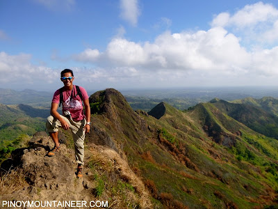
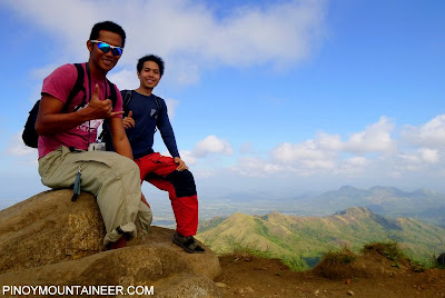
Features: Pine forests, mossy forests, Scenic grassland summit

BACKGROUND
The four classic trails of Mt. Pulag are Ambangeg, Akiki, Tawangan, and Ambaguio, and in the course of several hikes I have had the privilege of trying all of them. The recent years have seen Ambangeg becoming a tourist trail, and with hundreds of people on its main campsite during weekends, I think it is time to deemphasize the Ambangeg as the 'main' Pulag trail. Whether we like it or not, because of its easy access to the summit, people will flock there.

The purpose of this itinerary is to introduce a different Mt. Pulag experience, one that would appeal more to hikers, but in a way that is also doable within a weekend. It will be a radically different weekend: the unique trails you will pass through will span over 30 kilometers - thrice that of Ambangeg. In terms of hiking hours, we will also be looking at 10-hour days apiece, instead of the 8-hour total of Ambangeg. In terms of difficulty, I would give the Akiki-Tawangan a 7/9 compared to the 3/9 of Ambangeg. What I speak of is the Akiki-Tawangan Traverse, a very scenic and challenging hike that combines the the steep, pine-forested trail of Akiki and the long, mossy-forested trail of Tawangan, and between them, the grassland summit - providing a Pulag experience that has instantly become one of my favorite Cordillera hikes!

The Akiki-Tawangan is also combinable with a Mt. Tabayoc dayhike on the third day, making this a much more exciting option than the Luzon 3-2-1, which involves visiting Mt. Timbak. Although Timbak is a nice place, in terms of trekking hours, I am convinced that an Akiki-Tawangan-Tabayoc is a more reasonable option.

The first part of the hike involves ascending to the summit via the Akiki Trail, which can be accomplished in one long day, or two relaxed ones. The advantage of pushing Akiki Trail in one day is that it makes a "weekend Pulag" possible with the help of chartered jeepneys. On the other hand, by creating a four-day itinerary, availing of passenger buses on both ends is very possible. Overall, I would suggest a 3 or 4-day hike; with an optional Tabayoc, time permitting.

The steep ascent requires an altitude gain of over 1500 meters and it is not recommended for people who will not enjoy such a demanding task for one day. Options include camping in Eddet River, or more reasonably, Marlboro Country which has a water source and is close enough to the summit to reach it early in the morning. There is nothing complicated about the Akiki Trail: It's just ascents and pine trees all the way!

Past Marlboro Country, you will enter a mossy forest but this is not the mossy forest awaiting you in the hike. 2.5-3 hours from Marlboro, you will emerge into the grassland summit area of Pulag and within 30 minutes you will be at the summit.

From the summit, the Tawangan Trail is a very long but gradual descent through a mesmerizing mossy forest. If the Akiki is pine forest all the way, the Tawangan is mostly mossy, and this will go on for 7-9 hours on a descent. The only perceptible change is the increase in height of the trees as you descent - a natural consequence of varying climatic factors. Two-thirds into the trail, you will trek parallel to the Halong Creek, which doubles as a water source. When the descent is done, the village of Tawangan - with its friendly people and cozy and cheap lodge - is not far away.

For the peakbagger, climbing Mt. Tabayoc, Luzon's second highest, is very appealing since it is just a 3 or 4-hour return hike. This entails an additional day, but also makes the itinerary more relaxed.

ITINERARY

AKIKI-TAWANGAN TRAVERSE (2 days)

Day 0
2300 Bus from Manila to Baguio City

Day 1
0500 ETA Baguio City. Take chartered jeepney to Akiki, Kabayan.
0730 Stop to register at Visitors Center
0830 Arrival at Akiki trailhead; head to Ranger Station
0900 Register again and secure guides at Ranger Station
0930 Start trek
1130 Arrival at Eddet River. Early lunch
1230 Resume trek
1530 ETA Marlboro Country
1800 Arrival at Saddle campsite. Set up camp.
1900 Dinner / socials

Day 2
0400 Wake-up call / Breakfast / Break camp
0530 Proceed to summit for sunrise viewing
0630 Start descent via Tawangan Trail
0715 Enter mossy forest line
1200 Lunch on trail
1230 Resume trek
1430 Arrival at Brgy. Tawangan. Take chartered jeep to Baguio
2030 ETA Baguio.
2200 Take bus back to Manila

AKIKI-TAWANGAN TRAVERSE (2 days) + TABAYOC DAYHIKE

Day 0

2300 Bus from Manila to Baguio City

Day 1
0500 ETA Baguio City. Take chartered jeepney to Akiki, Kabayan.
0730 Stop to register at Visitors Center
0830 Arrival at Akiki trailhead; head to Ranger Station
0900 Register again and secure guides at Ranger Station
0930 Start trek
1130 Arrival at Eddet River. Early lunch
1230 Resume trek
1530 ETA Marlboro Country
1800 Arrival at Saddle campsite. Set up camp.
1900 Dinner / socials

Day 2
0430 Wake-up call / Breakfast
0530 Proceed to summit for sunrise viewing
0630 Break camp
0730 Start descent via Tawangan Trail
0815 Enter mossy forest line
1200 Lunch on trail
1300 Resume trek
1600 Arrival at Brgy. Tawangan. Stay in lodge

Day 3
0500 Breakfast / Prepare to leave villagee
0600 Take chartered jeepney to Lake Tabeyo
0700 Sidetrip: Lake Ambulalakao
0730 Arrival at Lake Tabeyo. Secure guide for Tabayoc
0800 Start trekking
1000 ETA Mt. Tabayoc summit
1030 Start descent
1145 Back at Lake Tabeyo
1200 Take jeepney
1800 ETA Baguio City; Take bus back to Manila

AKIKI-TAWANGAN TRAVERSE (3 Days)*

Day 0
2300 Bus from Manila to Baguio City

Day 1
0500 ETA Baguio City. Breakfast then proceed to jeepney terminal/chartered jeep.
0700 Take chartered jeepney to Akiki, Kabayan. Early lunch at any stopover.
1200 Arrival at Akiki jump-off; commence trek on steep trail.
1230 ETA Ranger Station. Register. Secure guides.
1330 Start trek
1630 ETA Eddet River; set up camp.
1800 Dinner / socials

Day 2
0400 Wake up call. Prepare breakfast.
0430 Breakfast
0530 Break camp
0700 Start 3-4 hr trek to Marlboro Country
1100 Have early lunch at Marlboro country (water source)
1200 Commence 3-hour trek through montane forest.
1430 End of forest line (2600 MASL); Reach Grassland.
1600 ETA Saddle campsite; set up camp.
1730 Optional assault to summit for sunset
1900 Dinner / socials

Day 3
0400 Wake-up call / Breakfast / Break camp
0530 Proceed to summit for sunrise viewing
0630 Start descent via Tawangan Trail
0715 Enter mossy forest line
1200 Lunch on trail
1230 Resume trek
1430 Arrival at Brgy. Tawangan. Take chartered jeep to Baguio
2030 ETA Baguio.
2200 Take bus back to Manila

*Also possible to add the Tabayoc day to this itinerary as a Day 4
**Note: Weather can greatly affect travel times due to road problems or even blockages which can set you back by an entire day. Check with the jeepney driver about conditions. Sometimes they cannot go to Tawangan too early because of the mud.

PRACTICALITIES
When to go. Mt. Pulag is accessible throughout the year, but it is much more advisable to climb it during the early months of the year, for many reasons. Bad weather, for instance, may not allow the jeep to reach the Ranger Station. Also, clouds may very well obscure the fabled Pulag views, which may lead to disappointment. Moreover, rainy conditions would make it even colder. Thus the advisable time frame for Pulag is between December-early May. However, Pulag may be climbed year round and if you're lucky you can have nice weather even in the so-called typhoon months of June to September.

Getting there. From Manila, Baguio is a 5-6 hour ride by bus; Victory Liner has hourly night trips (P460) as well as an option to take a three-across bus (P700-800). From Baguio, if you have a lot of time in your hands you can take the public bus to Kabayan (P150) that leaves at the Dangwa Terminal. If you wish to do the two-day or three-day options, it is best to charter a jeepney. Gina Epi, coordinator of jeepney drivers, may be reached at +63.919.816.9234. For the itinerary detailed above, the going rate for the jeepney transportation ranges from P13,000-14,000 (it is really quite far but still expensive; consider inviting more people to share the cost).

Registration and guides. The other contact is the DENR Park Superintendent for the Mt. Pulag National Park, Emerita Albas. She may be reached at +639196315402. She will contact the guides ahead of time. The Akiki-Tawangan itinerary is not included in their official list of guide fees, so you can negotiate a bit. For the two-day itinerary, I paid P2000 per guide. Mrs. Albas asked us to get two guides for security reasons, but as this itinerary is used more often, I think she will agree to just one guide for up to 7 persons. 

Camping notes. There are water sources in Eddet River campsite (obviously) and near the Marlboro country, and in the distal portions of the Tawangan Trail. Cellphone signal exists in many parts of the Akiki Trail but the Tawangan area has limited signal.

AKIKI-TAWANGAN TRAVERSE PICTURES

Proceeding to the summit from the Akiki Trail
Mesmerizing mossy forests of the Tawangan Trail
The beautiful and verdant paths of the Tawangan Trail
TRIVIA 
The blogger did the Akiki-Tawangan Trail as a two-day hike from April 20-21, 2013. This hike is narrated in Hiking matters #337-338, see links below:

MT. PULAG (AKIKI-TAWANGAN TRAVERSE)
Day 1: Akiki Trailhead -> Marlboro Country
Day 2: Marlboro Country -> Summit -> Brgy. Tawangan
Akiki-Tawangan Traverse pictures on PM Facebook

Hiking matters #339: Mt. Kalisungan Traverse to Mt. Atimla

$
0
0
The steep descent through grass marks the start of
the traverse from Kalisungan to Atimla
If mountains were people, then I suppose Mts. Kalisungan and Atimla are best friends - or a happy couple. These two peaks can always been seen together from various vantage points, including my very own neighborhood in Los Banos! Naturally, I've always been curious to check out Mt. Atimla, even as I have climbed Mt. Kalisungan several times.

During my most recent hike in Mt. Kalisungan, I requested my guide Bino to find a trail to Mt. Atimla as a traverse from Mt. Kalisungan's summit. This is not unprecedented: I know that hiking clubs in the past have done such a traverse before, referring to the two mountains as Mt. Nagcarlan and Mt. Calauan. So it would be nice to reestablish it as a more challenging variation of a regular Kalisungan hike. A week ago, Bino informed me that he has finished the trail, and so I decided that it was time to return to Calauan.
We started early - around 0630H. This time around, the ground was dry, unlike my past two hikes up the mountain which were both quite muddy. The ascent was straightforward and it can feel very humid and hot while hiking, but in two hours we were at the summit, enjoying the view of the lakes as well as the nearby mountains: we were early enough to see Mts. Cristobal and Banahaw before they got covered with clouds.
The fun begins with the traverse to Mt. Atimla, which was totally new to me (and to all of us). The descent initially featured going down through the highly-inclined east face of Kalisungan, with the view of Mt. Atimla. Then after fifteen minutes or so, we entered a woodland that teemed with red ants; several of us got bitten. I would have ignored it had I not remembered that I was also bitten by red ants in my previous hikes up the mountain!
The woodland trail was circuitous, and Bino himself was unsure about parts of it, but eventually we reached an altitude where we could see Kalisungan isolated all other peaks -- a unique perspective that shows its full glory. This, for me, is the most rewarding sight of the trek.

By 1120H, we were at the summit of Mt. Atimla, after almost five hours of trekking. As Bino put it, it looks like the summit of Mt.  Mabilog, except that it is larger and the terrain is more varied. It is almost a plateau, except that it's not very flat. Still, I think there is enough space for a small campsite. Unfortunately, there are no water sources throughout the trail - from the jumpoff all the way to the two mountains - so each of us brought 4 liters, at least.

The descent ought to have taken us to Brgy. Sta. Catalina, San Pablo, but since Bino was 'not too confident' about it, we decided to just head down Atimla towards the housing project in Brgy. Curba, Calauan. This took us less than two hours, and is probably the easiest access point up Atimla as a separate hike. It is unclear, though, whether it's safe to make it a trailhead, for security reasons.

Anyway, by 1430H we were already traveling back to the Brgy. Lamot 2 trailhead by trike, and from there I went back to Los Banos. In all, I'd say that the Kalisungan-Atimla Traverse is a great variation of the regular Kalisungan hike, with more challenges and rewards. Considering how close it is to Manila, it is a welcome addition to the roster of Southern Tagalog mountains!
Thanks to everyone who joined the hike!

PINOYMOUNTAINEER IN MT. KALISUNGAN
Hiking matters #118: Kalisungan, first climb of the year
Hiking matters #287: Mt. Kalisungan, revisited
Hiking matters #314: Twin Dayhikes Part I - Mt. Kalisungan
Hiking matters #319: Kalisungan, first climb of the year again!
Hiking matters #339: Mt. Kalisungan Traverse to Atimla 

Hiking matters #212: The descent from 369 Hut to Wuling Farm

$
0
0
TAIPEI, TAIWAN - More than a year after my first hiking trip, I have taken time to reminisce my previous hikes in this country and I realized that I have failed to write about Day 3 of the Snow Mountain hike! For the sake of completion, I will try to narrate this beautiful day of trekking in this blog entry.

Day 2 saw our dramatic ascent up the summit; it was dramatic because the weather was quite terrible and yet we succeeded in reaching 3886 MASL, the second highest point in the country! So our mood was festive that night at 369 Hut, even as the weather remained gloomy by the time we fell asleep.

When we woke up, however, the weather was perfect! We could see the other peaks in Shei-Pa National Park, as well as the pine forests that the other night mesmerized us the day before - the Black Forest. And we likewise had a wonderful outdoor breakfast before starting our descent.

We were so happy with the descent because we finally saw the summit of Snow Mountain, and all the way to the East Peak everything was splendid, including the arrow bamboo grasslands, and eventually, the junipers, the spruces, and the pines! Moreover, it just took us three hours to return to the trailhead from 369 Hut!
At Wuling Farm, we enjoyed the autumn leaves, oblivious of the problem that would confront us an hour later: the public bus that would bring us back to Taipei was nowhere in sight because of a landslide! Apparently this is not uncommon in this part of the world, due to the sheer geographic conditions in Central Taiwan. Fortunately, the very helpful hotel concierge helped us rent a van which took us to Taichung; from there we took the high-speed rail back to Taiwan, making it safety in time for the flight back to Manila!

Thank you so much Lear, Mafel, Julian, Doc Koko, Farah, and Coby for joining this hike that started my fascination for Taiwan's outdoors!
Viewing all 613 articles
Browse latest View live